anchor
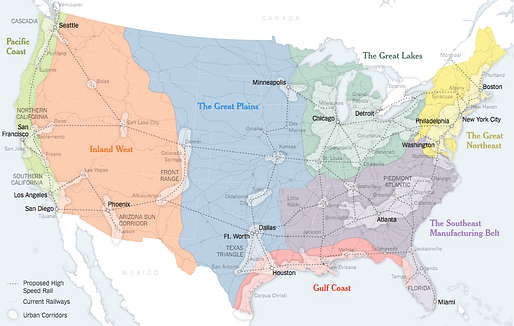
Connectivity, not territory: why we need to make a new map for the US

A map showing a possible future America, where boundaries are defined by economics and population rather than two century-old criteria. Credit: Sources: Joel Kotkin (boundaries and names of 7 mega-regions); Forbes Magazine; Regional Plan Association; Census Bureau; United States High Speed Rail Association; Clare Trainor/University of Wisconsin-Madison Cartography Laboratory. via the New York Times
America faces a two-part problem. It’s no secret that the country has fallen behind on infrastructure spending. But it’s not just a matter of how much is spent on catching up, but how and where it is spent. Advanced economies in Western Europe and Asia are reorienting themselves around robust urban clusters of advanced industry. Unfortunately, American policy making remains wedded to an antiquated political structure of 50 distinct states.
— Parag Khanna | the NY Times
More on the infrastructural mess in the US:
Similar articles on Archinect that may interest you...


11 Comments
Think the Country is smart enough to know the right thing to do, but too dumb to do it.
This is great, but Naptown needs a hi-speed direct connection to Detroit. I'd rather throw our future fortunes in with Detroit than Chicago.
^ Smartest thing I've read on the subject, agree with your "connect" to Detroit...smaller cities need to get real with it and invest in “connecting” instead of believing that they are the ones to connect to….don’t know about Indy politics, but most just can’t & won’t "get-it".
Need a direct rail from Omaha to Denver and Minneapolis to Seattle too. Omaha to Chicago too.
^ Why Omaha? Warren Buffet has a jet:)
Call it Denver to Chicago then, just happens to go through Omaha too.
That map isn't totally congruent with the actual cultural-social divisions in North America. Jayman's map is better.
Which is also similar to Joel Garreau's Nine Nations of North America:
I support high speed rail connections, but the divisions of the map create zones that are less diverse than the current state divisions. It also circumvents Appalachia, the poorest region in the nation, further isolating it from economic opportunity. And it ignores huge regions in the West solely because there is not a large enough city in the eyes of the author. The states were laid out to allow citizens to access their capital easily, a valid goal that is lost in this particular web.
The map as drawn only perpetuates movement to existing major urban centers. It should also promote the growth of new ones. The infrastructure argument is valid, but the proposed map is deeply flawed.
"The states were laid out to allow citizens to access their capital easily"
Maybe some states were, but certainly not all of them. The capitals of Washington and Oregon are certainly not centrally located.
Could you imagine their capitols being in Ellensburg, or Bend? But yeah, those are some seriously flawed maps...
Even if you want high speed rail for cities, this map makes no sense--prioritizing existing cities over future ones. The state system still provides the best blueprint for future cities, which will have use high speed rail to bring people to new metropolises inland. You don't want everyone living in the same two corridors. Obviously thought up by some technocrat that's never been outside of NYC-SF-LA
Block this user
Are you sure you want to block this user and hide all related comments throughout the site?
Archinect
This is your first comment on Archinect. Your comment will be visible once approved.