Subscribe to this Blog
About this Blog
Thoughts on the M.Arch I program at the Ohio State University, 2005-2009, plus additional work with OSU as a critic and lecturer.
Affiliated with:
Authored by:
Other blogs affiliated with The Ohio State University:
Recent Entries


5 Comments
oh. i get it. it's a pun.
yeah but do you get it?
very cool diagram
thanks
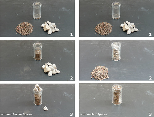
of course it's just a diagram, but the idea is that the big white rocks represent "anchor spaces" - the most prominent, public aspects of the program, as well as (by sheer coincidence?) the largest....
so one idea is that you'd locate these first, and fill in the rest of the program later, giving you a fairly dense, well-packed volume.
on the other hand - and this is perhaps more interesting - what if you took all the least-prominent spaces, and placed those first, essentially giving you a plinth on which to put the most important public spaces... and so what if maybe they all dont fit under the prescribed building height?
yes, but the conventional diagram is to have a major "anchor" space at each end of the circulation flow, with perhaps secondary "anchor" spaces located along that flow - all filled in with rest of the program.
not saying that is any good, just that it seems an obvious version of the diagram.
Block this user
Are you sure you want to block this user and hide all related comments throughout the site?
Archinect
This is your first comment on Archinect. Your comment will be visible once approved.