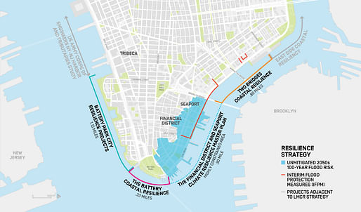

New York Mayor Bill de Blasio proposed a $10 billion plan to push out the lower Manhattan coastline as much as 500 feet, or two city blocks, to protect from flooding that’s expected to become more frequent as global temperatures rise. [...]
Portions of the extended land would be at 20 feet above sea level. The city can’t build flood protection on the existing land because it’s too crowded with utilities, sewers and subway lines, he said.
— Bloomberg
New York Mayor Bill de Blasio has unveiled the city's comprehensive plan to increase resilience in Lower Manhattan, a low-lying, highly critical area that has proven to be vulnerable to storm surges and flooding. The newly published Lower Manhattan Climate Resilience Study recommends extending the Manhattan shoreline into the East River to better protect the Seaport and the Financial District.
“Hurricane Sandy showed us how vulnerable areas like Lower Manhattan are to climate change,” said de Blasio in his public announcement. “That’s why we not only have to reduce emissions to prevent the most cataclysmic potential effects of global warming, we have to prepare for the ones that are already inevitable. Our actions will protect Lower Manhattan into the next century. We need the federal government to stand behind cities like New York to meet this crisis head on.”
"The Financial District and Seaport Climate Resilience Master Plan will bring a targeted focus to closing a gap in climate protection for the District in the long-term," explains the study. "These neighborhoods represent a unique convergence of high climate risk and few adaptation options due to a highly constrained waterfront that lacks the physical space needed to implement most large-scale adaptation projects. In the face of these unique conditions that make constructability of on-land adaptation measures infeasible, the City is recommending expanding Lower Manhattan’s shoreline into the water to deliver comprehensive protection from climate hazards and significant public benefits. Over the next two years, ORR and NYCEDC will complete the Master Plan, which will include a comprehensive design for the shoreline expansion and establish a new public-benefit corporation to finance, construct, and manage it."
5 Comments
Bjarke de Blasio?
Stop building and living at sea level literally up to the shore. The sea moves up and down, this isn’t new.
The sea moving up this much is new to humans in New York.
Given humans were migratory up until recently on the island of Manhattan and the oldest structure on the island is from the 1700’s humans really don’t have a history memory to where the sea has been. Look at maps of the area from that time. Even they are accurate. We inhabit land that is basically a series of plates that move including rising and falling. The earth moves on an axis and that isn’t even set precisely. The sun hits the earth at different angles over the existence of the planet.
The US Army Corps of Engineers (37,000 mostly civilian staff) has only been doing this since 1775. But, by all means, reinvent the wheel.
Block this user
Are you sure you want to block this user and hide all related comments throughout the site?
Archinect
This is your first comment on Archinect. Your comment will be visible once approved.