
How to Read a Croissant / Unfolding Spatial Violence III of III
In part I of this three part series “How to Read a Croissant / unfolding spatial violence,” I related Enric Miralles’ architectural layout of a croissant to the legibility of genocide in the Israeli forces’ seemingly arbitrary blockade of croissants into Gaza. Part II relates the croissant blockade to the denial of Palestinian humanity and locates the university as a place to disrupt this misrecognition of human kinship.
In this third part I will continue to reference the croissant as a site of data models, reading models of data capture and prediction through the croissant. From the croissant-scale, I invite you to read multiple modes of data capture at work in the spatial matrix of the occupation-as-starvation and its material logics. This spatial matrix includes house demolitions, zoning, crop destruction, the US Embassy, settler houses in Greater Jerusalem, and the limestone that constructs a continuity between them.
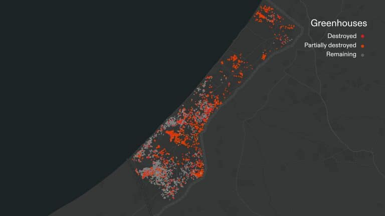
In February of this year, two months before the student encampments, I saw Shourideh Molavi present at the Center for Spatial Research’s workshop at Columbia University. The two-day workshop focused on research methods at the intersection of humanities, data sciences, and technology. Molavi presented a way of narrating and mapping the ecocide of Gaza’s orange groves through leaves and their exposure to airborne pesticides. Her work with Forensic Architecture reveals, “Since 2014, Palestinian farmers along Gaza’s perimeter have seen their crops sprayed by airborne herbicides and regularly bulldozed, and have themselves faced sniper fire by the Israeli occupation forces.” Combining satellite images with collaboration on the ground, Molavi’s research has tracked how the IDF’s ground invasion, financed by US military aid, actively destroyed agricultural fields in Gaza. In addition, from October 2023 to March 2024, the bombardment and ground invasion destroyed almost one third of the greenhouses in Gaza.
https://forensic-architecture.org/investigation/ecocide-in-gaza
Hunger has been not a side effect, but the goal and the method. Hunger falls within a wide rubric of violence that Israel is inflicting on Palestinians. Unlike air strikes, which require advanced weapons technology and flight-paths, hunger requires an extensive spatial matrix of occupation.
The attenuated violence of the occupation-as-starvation constructs itself upon specific but shifting performances of territory. The capacity of Israeli authorities to sift through aid trucks entering one singular checkpoint requires a host of other military buffer zones, walls, and checkpoints, as well as nodes of settler enclaves and the infrastructure that connects them. These specific performances of territory-as-violence constitute what anthropologist Jeff Halper calls the “Matrix of Control.” Design and planning are deeply implicated in the matrix of control that extends across the occupied territories of the West Bank, East Jerusalem, and Gaza Strip. The matrix of control over Palestinian people– a matrix that extends to Palestinian agricultural fields, greenhouses, and bellies– requires architecture, masterplans, suburban enclaves, and local stone.
As Eyal Weizman writes in Hollow Land: Israel’s Architecture of Occupation (2017), part of the role of architecture in the Occupied Palestinian Territory is to blur the facts of occupation.
“Architecture– the organization, form and style by which these neighborhoods were built, the way they were mediated, communicated and understood – formed a visual language that was used to blur the facts of occupation and sustain territorial claims of expansion.” (52)
Such blurring enables the occupation to be normalized and rendered as civic life, even as it entails apartheid, dispossession, and defiance of international law. Part of the blurring occurs through material and spatial continuities that absorb illegal settlements into the matrix of control. Within the spatial logic of post-1967 occupation, Jerusalem has played a multiscalar role in this blurring of facts. An American observer can easily recognize the spatial form that coheres political annexation, the wall, illegal settlements and military outposts. It is ex-urban sprawl. As B’Tselem – The Israeli Information Center for Human Rights in the Occupied Territories recounts the 1967 annexation of East Jerusalem:
"In June 1967, immediately upon occupying the West Bank and the Gaza Strip, Israel annexed some 70,000 dunams [1 dunam = 1,000 sq. meters] of West Bank land to the municipal boundaries of Jerusalem and applied Israeli law there, in breach of international law. The annexed territory greatly exceeded the size of Jerusalem under Jordanian rule (about 6,000 dunams), encompassing approximately 64,000 more dunams. The additional land belonged, in large part, to 28 Palestinian villages….Israel included some lands belonging to villages near Jerusalem within the city’s municipal jurisdiction, yet left the owners outside it." https://www.btselem.org/jerusalem
In defiance of UN resolutions and often even in defiance of Israeli law, the suburban sprawl of Greater Jerusalem intensified in this century.
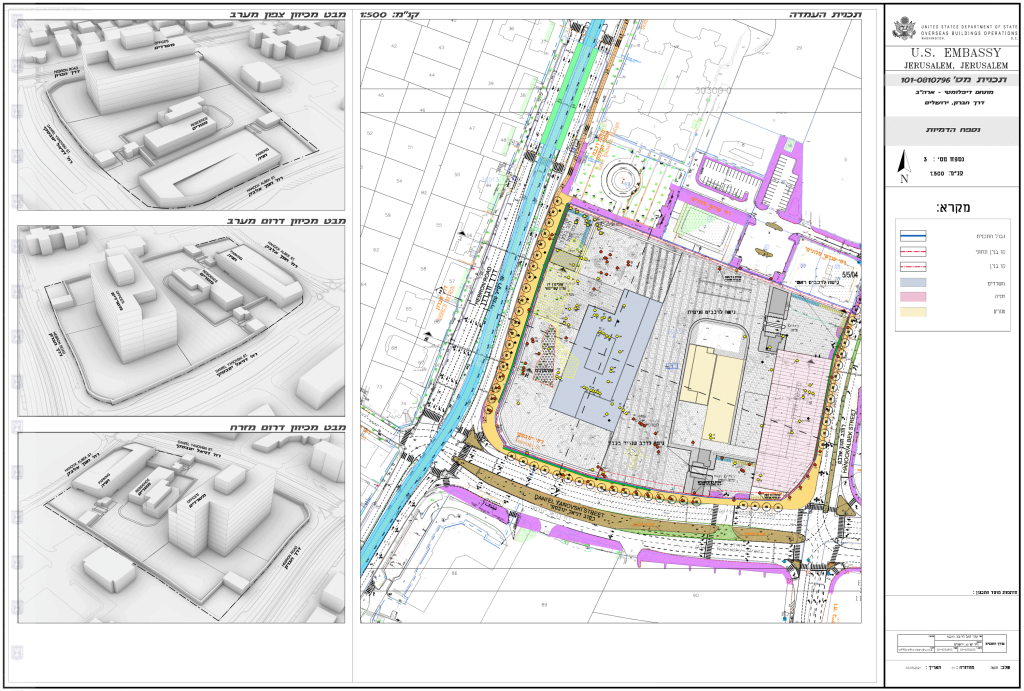
The new US embassy in Jerusalem – announced by President Trump but continued under President Biden – continues this blurring of facts. It is now an outlier among international embassies, which remain mostly in Tel Aviv because Jerusalem’s status remains disputed under international law. The new US embassy enacts a highly charged blur– from its regulated limestone material to the contested land claims that it is sited upon to the geopolitical signals the new location sends.
https://theintercept.com/2022/12/15/us-embassy-israel-biden-jerusalem/
Eyal Weizman explains the significance of Greater Jeruselum to the dual normalization and intensification of the Zionist occupation of the West Bank–
"An outer, second circle of settlement – termed by Israeli planners the ‘organic’ or ‘second wall’, composed of a string of dormitory suburbs – was established beyond the municipal boundaries, extending the city’s metropolitan reach even further… ‘Greater Jerusalem’ became thus a sprawling metropolis reaching the outskirts of Ramallah in the north, Bethlehem in the south, and Jericho in the east…” (Hollow Land, 50-51)
The pattern of diffuse ex-urban and suburban sprawl has intensified in tandem with the matrix of control. The sprawling metropolis forms an alibi for annexation of Palestinian territory, in defiance of UN resolutions.
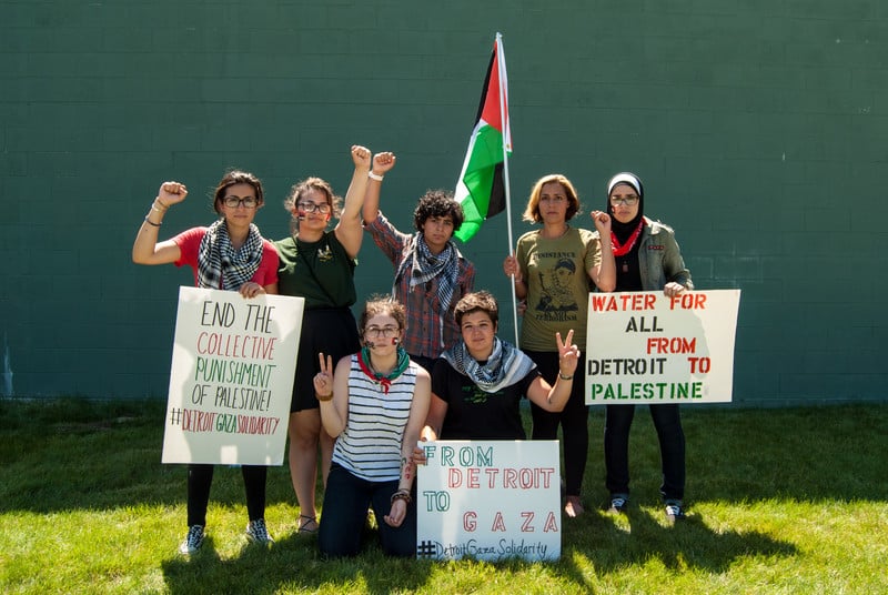
Some of the most racially segregated large cities in the US exhibit a similar pattern. I have written about the suburban control of water and sewage infrastructure in Detroit, a pattern I call watercraft, which also traces back to the mid 1960s. In Detroit the pattern of watercraft enabled the state of Michigan to declare emergency management over the majority Black city and force Detroit residents to pay 10 times higher water bills than suburbanites pay. Detroiters– community organizers, artists, activists, and students– recognized the shared spatial logic of Emergency Management in Michigan and the blurred sprawling matrix of control in the Occupied Palestinian Territories.
In 2014, when Rashida Tlaib was still a Michigan state legislator, Over 1,000 Detroiters demonstrated for Detroit human rights and Palestinian liberation near the Wayne State University campus.
https://electronicintifada.net/blogs/jimmy-johnson/detroit-rallies-largest-turnout-palestine-years
This is the point when it starts to sound like I cannot possibly know enough to write about this. Did I live in Detroit long enough to write properly of its infrastructures and activism? How could I possibly compare Detroit and Jerusalem? Am I talking about East Jerusalem or West Jerusalem, or when does that distinction matter? It would take a careful historian to explain the dynamics or even capitalize the locations correctly, and I am not a historian. I have never been to Israel or Palestine. What makes any of this spatial analysis or reading legitimate?
These questions– as specific as they are to Gaza or Jerusalem or Detroit– might also be asked of a croissant. In 2020 computer scientists informed by Enric Miralles’ drawing and procedures returned to the croissant as a model. They work from Enric Miralles’ “COMO ACOTAR UN CROISSANT / HOW TO LAY OUT A CROISSANT: El equilibrio horizontal / Horizontal equilibrium” as a representation of complex geometry. Their published case study “A point-based redesign algorithm for designing geometrically complex surfaces. A case study: Miralles's croissant paradox” relinquishes Miralles’ ambition to layout the croissant as a floor plan. Instead, their study repurposes Miralles' techniques toward a procedure to represent and design complex surfaces.
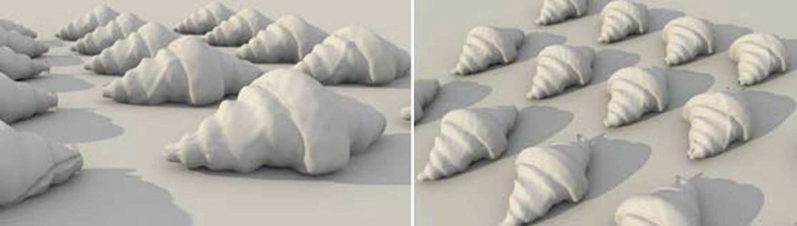
The computer scientists compare the results from modeling the croissant through NURBS and polygon meshes to modeling from a point cloud with a LiDAR scanner. They include a 3rd option, which tweaks the LiDAR results through genetic algorithms. The work seems to be bringing Miralles’ proposition up-to-date with contemporary technologies and computation methods. Not only can the croissant be accurately modeled, but the geometry can be automatically generated in such a way that creates artificial variants.
"Fig. 14 Croissant originated from the genetic morphogenesis algorithm. Diversity was achieved, since each mutant surface is slightly different"
This croissant case study in image processing has, unfortunately, completely excised the architectural work and significance from Miralles’ thought piece. These croissants have no inside. The croissant here is not cut in section or drawn in plan as something that we might imagine as occupiable or a form that might even be produced at a scale to be inhabited. Miralles’ use of section and plan are simply deployed here as means to form the outside of an object and render it knowable at different levels of accuracy or differentiation. In the case study, accuracy and differentiation slide into each other. Are we impressed by the rows of croissants because they look like rows of actual croissants on a baking sheet, in a way that they wouldn’t if they were all exactly the same? Here the data capture methods of LiDAR have been combined with the predictive methods of generative algorithms to render something plausible but opaque in its methods and intent.
One aspect of Miralles’ layout of the croissant that deserves further attention is that the drawing begins with a technology for electronic reproduction – the photocopier. When architects talk about the Miralles’ Croissant – and we do bring it up fairly often– we tend to skip over the photocopier. The photocopier, an electronic photographic technology, initiates the first step in Miralles’ architecturally laying out the croissant. The layout stages photography as an instrument of producing measurability, not rendering an image. The photocopier pulls the croissant into a realm of fact by making a one-to-one image, whereby the croissant becomes an object. The computer scientists have proposed using a LiDAR scanner instead of this photocopier. But without a rubric such a floorplan, without a way of imagining into the croissant, they remain on its outside, vacillating between various modes of interpolating its surface.
The matrix of control evidenced in the Occupation of Palestinian Territories does not become less verifiable because it resonates with aspects of Emergency Management in Detroit. That resonance might be witnessed from a distance, even if the violence does not touch our own bodies. Even as we read these resonances, we can develop protocols that undo parts of the matrix of control– such as the move for universities to divest from companies profiting from genocide in Gaza. These protocols may be limited and finite and involve some shortcuts. If they are useful protocols they will expose the violence unfurling at the same time that they recalibrate and disentangle our complicity with that violence. No one needs a perfectly accurate image of this cruelty, especially not from the outside. The will toward the accurate accounting of the violence– exactly how hungry is starving, exactly how much control is apartheid, how much death is genocide, the endless strike videos– often cannot be disassociated from what seem to be the aesthetic and supremacist pleasures of ethnic cleansing.

Posts are sporadic. Topics span architecture, urban design, planning, and tangents from these. I sometimes include excerpts of academic articles.
No Comments
Block this user
Are you sure you want to block this user and hide all related comments throughout the site?
Archinect
This is your first comment on Archinect. Your comment will be visible once approved.