
Is there any more concise record of globalization and its various militaristic and managerial operations than the Coordinate Reference System options in your standard GIS software?
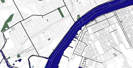
For a project sited in Detroit, I have started building a Geographical Information Systems (GIS) map focused on downtown Detroit neighborhoods and the waterfront border with Windsor, Canada. The project is especially concerned with bike paths - really any alternative to automobiles. Biking is already established in neighborhoods on either side of this international border - through Mexicantown and Corktown on the Detroit side and downtown Windsor on the Canadian side. Part of what I am looking at is the possibility of local international bike paths.
In the process, of course, I am bringing together data with varied Coordinate Reference Systems.
 Windsor, Canada, above, with bike paths in heavy black and potentially skate-able sidewalks in dark gray.

I have not yet got the Detroit vectors (Tigerline data) to line up with the Windsor vectors. In addition to Coordinate Reference System differences, there's also your standard feet vs metric import kinks to figure out.
In the process of working through this typical technical issue, I have scrolled through the entire list of Coordinate Reference Systems offered as default options in the free open source GIS software I am using (QGIS). It's a fascinating list. It reminds me of Borges' encyclopedic list of animals that Foucault cites in The Order of Things.
Some dates ring as major markers in the history of re-drawing borders. Many places are repeated with multiple years, sometimes with shifting names. Bogota, Tokyo, and Pulkovo seem to be the most repeated locations. Occasionally an engineers association or standards body is referenced, but it seems only to show that the standard is outdated or in the wrong language.
A small arbitrary sample:
American Samoa 1962 | EPSG:4169
Ancienne Triangulation des Ingenieurs | IGNF:ATIGEO
Belge 1950 | EPSG:4809
Belge 1950 (Brussels) | EPSG:4809
Egypt 1907 | EPSG:4229
Egypt 1930 | EPSG:4199
Egypt Gulf of Suez S-650 TL | EPSG:4706
This may seem far afield from Detroit bike paths. But as I am looking at the proximity of these two downtowns that could so easily meet, I am drawn to think through the relationship of borders and data, coordinate systems and power, as well as the somewhat raw history embedded in the tools that we use.


Posts are sporadic. Topics span architecture, urban design, planning, and tangents from these. I sometimes include excerpts of academic articles.
1 Comment
The maps are combined now. I had to change the project setting in QGIS to set CRS "on the fly." It is perhaps not surprising that Canada has so much nicer data than we do in the States (sidewalk widths even). I am hunting for more bike path info that I can actually get in vector form.
Block this user
Are you sure you want to block this user and hide all related comments throughout the site?
Archinect
This is your first comment on Archinect. Your comment will be visible once approved.