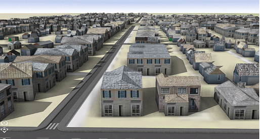

A team of researchers from The Ohio State University has developed a machine learning technique that converts old urban maps into three-dimensional digital models. According to the team, the models could potentially revolutionize research involving historic neighborhoods and the economic impact of their demolition.
The study, recently published in the journal PLOS ON, involved extracting and digitizing data from Sanborn Fire Insurance maps. The maps, created during the 19th and 20th centuries and frequently updated, were used by fire insurance companies to estimate their liabilities in about 12,000 U.S. cities and towns.
"We now have the ability to unlock the wealth of data that are embedded in these Sanborn fire atlases," said Ohio State Geography Professor Harvey Miller, a co-author of the study. "It enables a whole new approach to urban historical research that we could never have imagined before machine learning. It is a game changer."
Yue Lin, a geography doctoral student at Ohio State and co-author of the study, used machine learning tools to extract details about individual buildings from the maps, such as their locations, footprints, the number of floors, their construction materials, and their primary use. The researchers applied their machine learning technique to two neighborhoods in Columbus, Ohio, which were largely destroyed in the 1960s for the construction of Interstate-70. The neighborhoods, Hanford Village and Driving Park were thriving Black communities prior to the highway's construction.
By utilizing 13 Sanborn maps from 1961, the team was able to extract the data and generate digital models of the neighborhoods. The machine learning model demonstrated an impressive level of accuracy - approximately 90% for building footprints and construction materials. "We are able to get a very good idea of what the buildings look like from data we get from the Sanborn maps," said Lin.
According to the team, the technique developed in the study could be applied to almost any of the 12,000 cities and towns that have Sanborn maps, opening up new opportunities for research. Researchers could recreate neighborhoods lost to natural disasters, urban renewal, and other changes, and assess the economic impact of such losses. Furthermore, it could be used to study the urban heat island effect caused by replacing homes with heat-absorbing highways.
“There’s a lot of different types of research that can be done. This will be a tremendous resource for urban historians and a variety of other researchers,” Miller said. “Making these 3D digital models and being able to reconstruct buildings adds so much more than what you could show in a chart, graph, table, or traditional map. There’s just incredible potential here.”
This article is part of the Archinect In-Depth: Artificial Intelligence series.
No Comments
Block this user
Are you sure you want to block this user and hide all related comments throughout the site?
Archinect
This is your first comment on Archinect. Your comment will be visible once approved.