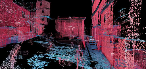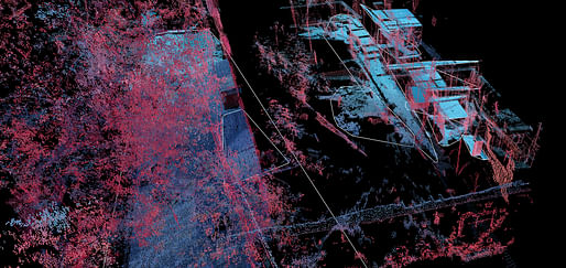
The MIT Senseable City Lab has unveiled their “Favelas 4D” project, dedicated to mapping the largest favela in Rio de Janeiro, Brazil. Using 3D laser scanning technology to analyze the urban landscape of Rocinha, the project seeks to understand and quantify the architectural logic of one of Brazil’s famous informal settlements.
Brazil’s favelas consist of dense, multilayered, informal settlements that dot the hills of large cities such as Rio de Janeiro; their urban chaos contrasting starkly with the planned neighborhoods surrounding them. This spatial complexity makes the favelas a difficult terrain for typical open-source mapping tools such as satellite imagery and Google Street View, leaving much of their labyrinthine cityscapes unmapped and misunderstood.

On the importance of mapping these informal settlements, the MIT team explains; “The global trend of urbanization is not limited to shining downtown districts and masterplanned developments: of the roughly 4 billion people who live in cities worldwide, almost 1 billion reside in informal settlements constructed without official urban planning. These settlements are built spontaneously and competitively, resulting in a complex urban morphology. People living in informal settlements are largely excluded from city infrastructure and services—exposing them to a variety of public health and security challenges—but they continue to absorb new generations of residents as the world’s exploding urban population outpaces the availability of official affordable housing.”

For Favelas 4D, the MIT team led by architect and professor Carlo Ratti used point-cloud data from LiDAR scans taken at street level in the favela, forming an ultra-high resolution 3D digital environment. The advantage of using LiDAR over other mapping methods for the study lies in its unparalleled precision; using laser pulses to measure distances and map miniscule points in digital space. LiDAR mapping of the favela’s form can reveal patterns of unregulated construction, identify logic among the informality, and reveal insights that can guide interventions and policies to improve safety and welfare in Rocinha and other favelas.
The augmented understanding of Rocinha attained by LiDAR-based mapping can begin to mitigate against systemic problems within Brazil’s favelas. These can include struggles with property trading due to a lack of land tenures, landslide risks due to unstable terrain, or water and air quality due to the limited infrastructure serving the districts. However, Ratti also sees the study as an opportunity for urban planners to learn from the favelas. “Despite their challenging circumstances, favela residents have developed ingenious and responsive ways to build their own urban systems,” he says. “This bottom-up planning process and the complex architectural forms it produces can challenge the standard way of designing cities.”
As informal settlements around the world continue to grow, Ratti’s team believes that researchers and planners must integrate such settlements with visions of global urban futures, by both learning from their unique development patterns, and improving their access to the benefits of formalized urbanism. In this context, Favelas 4D demonstrates the potential for LiDAR data and quantitative analysis to form an integral part of this complex mapping process; an example of how point-cloud data systems can help us understand and shape the cities of tomorrow.
The project was developed in collaboration with Rio de Janeiro’s City Planning Commissioner, Washington Fajardo. The web visualization of the project can be found here.
6 Comments
LiDAR has been around for a while
Interviewed with a firm that did a lot of work with this 8 years ago....
Did the layout for a thesis project in a student publication where the designer did this with a hacked up x-box connect 9 years ago...
You'd think that instead of mapping slums they would put effort into eliminating them.
Which is probably why they are mapping them - for developers. Just think of all that cheap land! Also great for video game development.
I wonder how much of this already made available (read sold) to Brazilian police?
I love the magenta-cyan colour combo...
Block this user
Are you sure you want to block this user and hide all related comments throughout the site?
Archinect
This is your first comment on Archinect. Your comment will be visible once approved.