The Three Cities is a strange place. With its multiple names, it resembles a realm straight out of George R.R. Martin’s mind, with an Orwellian socialist twist. Three micro cities jutting out like the open beak of a seagull into the Grand Harbour (a series of harbours within a larger harbour).
On entry through a tunnel-breach in the Cottonera Lines, flanked by War of the Worlds like cranes, over tarmacked roads, around soot stained buildings, under throngs of laundry hanging from balconies above, you arrive in the heart of it – Misraħ Gavino Gulia, at the head of Dock 1.
Wedged in between 16th century limestone bastions and Cold War post-war architecture, Dock 1 is found at the end of Dock Yard Creek, spreading on the shores of Vittoriosa, Cospicua and Senglea (The Three Cities). Malta’s development and importance owes much to this area. The Grand Harbour, specifically Dockyard Creek, have been used as a harbour since the Roman period.
The settlement of the Knights of the Order of St. John (1530) in Birgu (Vittoriosa) contributed to the extensive development of naval activity within the area. This expansion was sustained throughout the 250 years of the Knights’ rule. Even after the construction of Valletta, Dockyard Creek was to retain its popularity, probably due to the easier accessibility to the shores and surrounding settlement.
The French (1798-1800) never realistically had the time nor the opportunity to have any lasting impact on the harbours. A few years later the maritime trade was to boom again, this time under the occupancy of the British Empire.
Two attempts to build a dry-dock within the Three Cities area had failed (1806-1816), until 1841 when William Scamp (1801-1872), a civilian-architect for the British Navy, proposed a new dock for the Admiralty.
The first proposal comprised of: the dry-dock; an engine room at the head of the dock; two sheds for wood on either side; underground coal vaults; and a boundary wall. Scamp later recommended the purchase of surrounding properties in order to extend the yard. New buildings were included in the plan on both the Senglea and Vittorisa side. The project was completed in 1848, and by 1851 all Dockyard Creek belonged to the Admiralty.
Under the British, the area sustained a further century of development, to be reduced to rubble during the German air raids of World War II. But the biggest change came under Maltese sovereignty in 1972-73, when the dock was once again refitted, which led to the demolition of several buildings.
Today none of the original buildings on the Vittoriosa side of the dock remain.
The dismantling of Dock 1 and the decrease in economic importance of the dockyard, impacted negatively on the socio-economic fabric of the Three Cities, resulting in decades of decline.
The legacy of the dockyard ultimately was one of social separation – the entire waterfront was alienated from its surrounding community.
The proposed Cottonera Regeneration Project, by the Government of Malta and aided by funds from the European Union, aims at improving the Three Cities area and its waterfront, with Dock 1 to be considered a critical nodal-link in achieving the sustainable regeneration of the whole area.
In 2008 the Government of Malta adopted the landscaping phase of Architecture Project’s (AP) masterplan for the area. Until the landscaping project was implemented, the waterfront was walled off to the public – the big closed red gate at Misraħ Gavino Gulia marked the disuse of the dock. For any regeneration to commence, both physically and socially, the removal of barriers to the waterfront was of the utmost importance.
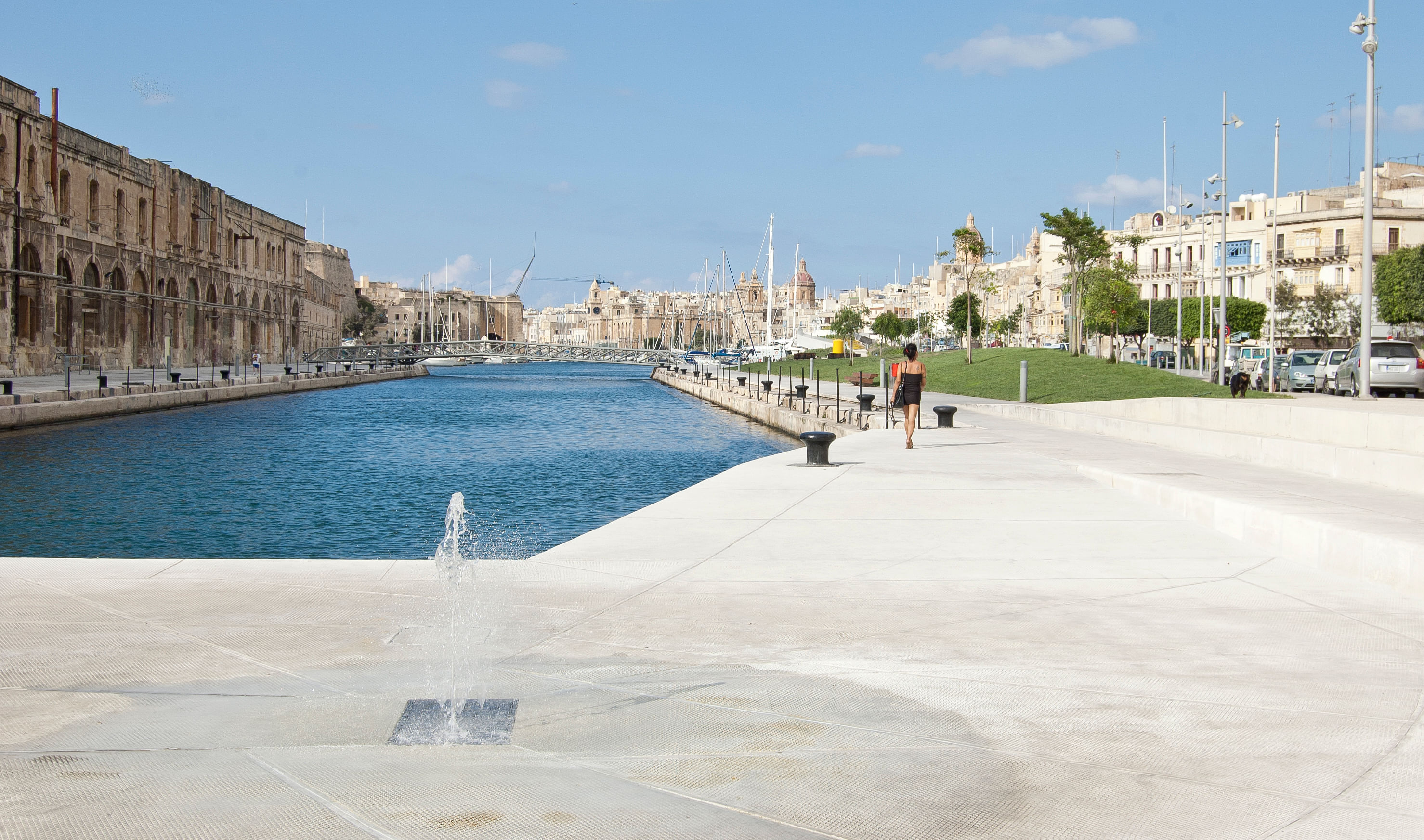
The Creek once again unites, rather than divides the residential quarters of the Three Cities, through a continuous 2.5km long promenade, linking Senglea’s and Vittoriosa’s waterfronts with gardens and public spaces, retaining the industrial heritage of the dockyard.
The landscaping of the waterfront and public spaces around it can be viewed as a series of nodes (space of urban-gravitas).
Misraħ Gavino Gulia, retained as an open piazza, with the removal of the gate and wall, it now extends to the water’s edge. Its landside perimeter is lined with shops and bars, turning the space into an established town-centre and gateway for visitors and locals to access either side of the waterfront.
Each node is linked through the waterfront and street level promenade; a series of lawned dunes, rising and disappearing into laid paths, creating tiny pockets of public yet personal spaces, with the use of designed public-furniture; steel strapped wooden beam benches; concrete cubed seating and tables; all elements recalling the dockyard’s long industrial identity.
Triq ix-Xatt ta’ Bormla runs the path to the Cospicua waterfront and Piazza Paolino Vassallo. Unlike the more traditional function of Misraħ Gavino Gulia, this plaza with an old theatre, Socjeta' Filarmonika San Ġorġ (band/social-club), and other bars, is an opportune space to host social and cultural events, becoming one of Malta’s prime public cultural spaces, appealing to the locals as well as other cultural visitors.
From here you could go either of three ways; across the new connecting bridge, spanning 45 metres over the creek into Senglea, entering a stepped plaza, which again is set to be activated as an open cultural space (the Senglea side is part of another phase of the encompassing regeneration plan); continue through the dunes along the Cospicua waterfront; or ascend, past the Phytoremediation Tanks (see below), towards the belvedere, from where you obtain uninterrupted views of Dock 1, facing Senglea.
Below the belvedere is storage space for the local maritime activity, and by the water’s edge a landing platform and waiting area for the various ferries servicing the area.
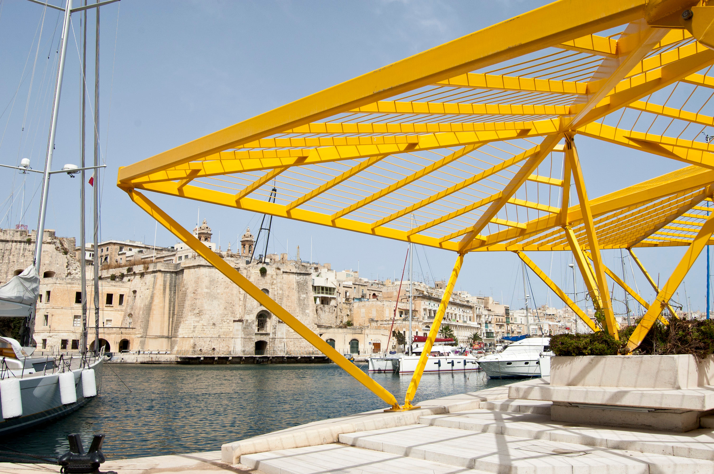
Further along the waterfront, a yellow steel framed pavilion with planters at its base creates a natural creeper-canopy over diners.
The promenade continues towards the Birgu Waterfront, via Xatt ir- Risq, past Vault no.0 and a new public convenience, arriving at the Freedom Monument and the steps of the Church of St. Lawrence.
Vault no.0 houses NEPTUME, which forms part of the sustainable side of the landscaping project.
NEPTUME (No-Discharge Energy-Efficient Prototype for the Treatment of Urban Municipal Effluent) is a research project done in collaboration between AP, the Biology Department at the University of Malta, Argotti Botanical Gardens and the Water Services Corporation (WSC). A wastewater treatment plant, it purifies municipal waste from local sources.
The process passes the wastewater through various filtering methods which include Moving Bed Biofilm reactors (MBBR) with microorganism catchers that remove the soluble pollutants from the wastewater (namely Ammonia and Biological Oxygen Demand); a revers osmosis system; and the phytoremediation tanks (found up by the belvedere), equivalent to constructed wetlands, the wastewater passes through a process of decontamination by using water-based vegetation (Macrophytes) to absorb and break down remaining pollutants.
This filtered wastewater is now fit for use as irrigation for the surrounding vegetation and landscape. The other supply for irrigation comes from the reconditioned historic water reservoirs from the Knights’ and British periods. These reservoirs are used to store and supply rainwater for irrigation and the new fountains.
Another sustainable consideration was the lighting of the open spaces. This had to reflect the low energy expenditure that the project’s philosophy dictated. The energy outlay of the new LED lighting is in fact equivalent to that of no more than a few households.
The Dock 1 landscape project has been in the making for a long time. Through dialogue with the local councils, local businesses, traders and NGOs, the project reads, as it should: A relative design for the needs of a community and area that for decades has suffered a decline in prosperity.
As stated before, the social and physical embellishment of the Dock 1 area is only but a part of a greater sustainable regeneration of this strangely unique portion of Malta’s identity.
Status: Built
Location: Cospicua, MT