anchor
Ring Roads of the World

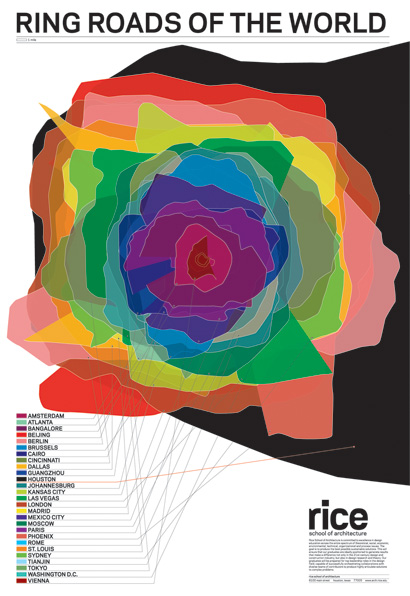
When I moved to Houston for graduate school, the common response from the LA/NYC crowd was "Oh, well Austin's pretty cool." Too many people have been visibly shocked when I mention Houston is the 4th biggest city in the US. So, I love the extraordinary shift the poster "Ring Roads of the World" designed by Thumb, provides to thinking of major cities with extensive networks of motorways. The poster maps peripheral highways of 27 of the world’s largest cities. Layered on top of each other almost all the cities form a tight, bright rosette composition; except the quiet, dark figure in the background. The Houston 610 loop bleeds off the page, giving me some kind of satisfaction in knowing the complexity Houston's size brings to those of us practicing within that big, black blob.
Thumb, is a Brooklyn-based graphic design office, founded by Rice University Alumni Jessica Young and Luke Bulman who both received Master of Architecture degrees from Rice University, in Houston, Texas, in 2002 and 1998.
Ring Roads of the World
Rice School of Architecture, 2009
22 by 32 inches
Production by CPY, Houston
"This poster is designed as a sort of calling card for Rice School of Architecture, located in Houston. We collected ring roads from 27 international cities and layered them all at the same scale. As it turned out, Houston has the largest system of those we surveyed. (Beijing was second)"
http://www.thumbprojects.com/index.php?/recent/ring-roads-of-the-world/


9 Comments
I absolutely love this poster. A lovely piece of graphic design.
...by the way, Thumb was recently featured on Archinect:
Working Out of the Box...
Houston, the big black blob... But seriously it does seem to surprise people. Even i forget sometimes.
actually, for Houston, there is more than one "ring road".
you can do a 'ring road' around the downtown, by going south on I-45, then getting onto 59 going east and north, then getting on I-10 going west, until you are back at I-45.
or there is the obvious 610 loop.
but now there is also the Sam Houston Parkway (or Beltway 8), which is another, more outer loop. wonder how that compares to other cities.
howdy Melissa. welcome to the school blogs!
hmmm, LA doesn't have a 'ring road' too many geographic constraints. that's too bad they didn't try figure out how the california love affair with highways compares.
hey melissa, glad there's some houston representation going on!
Come on, what other ring road has a scale model of the Forbidden City AND a strip-mall replica of the Doge's Palace? Houston rocks. You'll love it.
The big blob is not a representation of I-610. In fact it's a representation of the proposed Grand Parkway, the third and outermost ring road of Houston. In actuality, it exists today only in a few farm roads and many proposals for development. So if you represented Houston's largest existing ring road, Beltway 8, it would be considerably smaller.
I grabbed this poster from the UT Austin SOA as soon as I saw it-- it's wonderful.
Block this user
Are you sure you want to block this user and hide all related comments throughout the site?
Archinect
This is your first comment on Archinect. Your comment will be visible once approved.