
SWA’s Summer Student Program challenges students to reconfigure established systems of infrastructure and landscape, adapting regional developments within a preexisting cultural environment. In its fifth year, the program has dealt mostly with California’s diverse terrain, and now turns its focus to the bedraggled yet beloved Los Angeles River. Seven students from universities worldwide join SWA for four weeks of on-site practice, followed by five weeks of internship in an SWA studio.
The Los Angeles River presents a unique challenge as a confluence of ecological, jurisdictional and cultural concerns. In an arc echoing the coastline, the 51-mile long concrete channel stretches from the San Fernando Valley, north of the Santa Monica Mountains, to its ending mouth in Long Beach. In its current state, it is hardly a destination among Angelenos -- only recently were its waters opened to recreational use, for the first time since the riverbed was paved with concrete in the 1930s for flood control. But there are many nodes and stretches along the river that are highly visible and highly trafficked, and the whole stretch begs for development.
SWA’s Student Program joined the fray of L.A. city officials and the Army Corps of Engineers to generate musings on site-specific development projects for the river. Efforts to make the river more of a magnetic boulevard and less of a repugnant waste-zone have really taken hold in the last few years, including designs for comprehensive bike paths, bike-in film screenings, iconic bridges, business developments and functional art installations. SWA’s Student Program joined the fray of L.A. city officials and the Army Corps of Engineers to generate musings on site-specific development projects for the river. Their plans then received feedback from a panel of judges that included landscape architect professors from USC, the Deputy Chief of Urban Projects & Watershed Planning Division, and representatives from the Department of Public Works and advocacy group, Friends of the L.A. River.
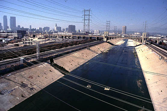
The river could become a kind of Pygmalion story for tourists and locals alike. Development ideas are churning up a lot of excitement, with hints that they could play a heavy role in L.A.’s bid for the 2024 Summer Olympics. The river plays a complex role in L.A.’s image -- as a physical boundary, a recreational destination, a residential backyard -- and as nearby projects in Union Station and Boyle Heights draw more attention nearby, the river could become a kind of Pygmalion story for tourists and locals alike. Ying-Yu Hung, Managing Principal for SWA’s Los Angeles location, believes that the river could be to L.A. what the High Line is to Manhattan, using landscape and ecology to form a “green network of ecological vibrancy”.
The students’ first task was to choose a location from fourteen pre-determined sites, selected by SWA and the City of Los Angeles for their relative lack of attention in previous planning efforts. The river’s 30+ miles that run through Los Angeles are in no way uniform -- its terrain is as diverse as the 20 different neighborhoods it cuts through, supporting vegetation and wildlife that had to be incorporated into the regional plan. This gives each student the chance to develop an idiosyncratic project specific to the surrounding landscape, and taken together, the seven plans would neatly express the diversity along the L.A. river corridor.
After being immersed in the landscape, meeting with the Army Corps of Engineers and performing research on the area, the students chose their site and began designing their installation and its presentation to the review board. The following is a selection of their work:
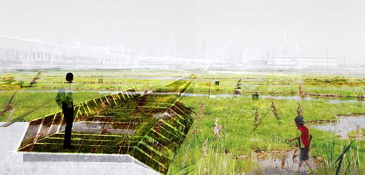
Let the Show Begin, Marta Gual-Ricart, University of California, Berkeley.
The Crown Coach Site can be the point where ‘landlocked’ residential and industrial neighborhoods get to ‘touch’ the river. The design allows for ecological habitats, water filtration by phytoremediation treatments and the prevention of disastrous flood events…and has the potential to be an incubator for CleanTech Businesses, which could then spread along Santa Fe Avenue as a new ‘motor’ for industry in the city.
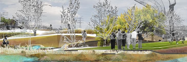
Topo-Infrastructure for Health, Stephanie Kopplin, University of Texas, Austin.
For the local community, the establishment of ecologically-oriented parkland would increase recreational opportunities for park-poor communities. At the scale of the river system, the creation of an educational storm water nursery could serve as a source and central maintenance site for other parkland and open space along the River. In both instances, the site could become a catalyst for the maintenance of both community health, and ecological infrastructure[...]
Layered into the design were proposals to collect, treat, and store the runoff of the subwatershed (which includes the parking lot of the Dodger’s stadium) to provide irrigation for the nursery, to establish an over/under the rail bridge to the eastern bank via connection to an ‘open-space island,’ and to link various activity circuits for walking, running, and cycling.
Stairway to the Hill, Esther Korteweg, Van Hall Larenstein, the Netherlands
Amphibious houses are a modern way to deal with climate change in the Netherlands (offering) a new method of land use by the L.A. River. When the water level rises the house will float and move along a guiding pile, keeping it in its location… safe and able to adapt to variable water levels.
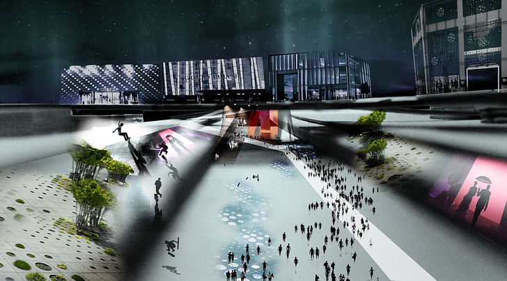
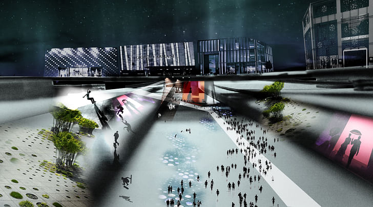
A Potential Fashion Park, BinBin Ma, Harvard GSD.
The existing urban grid has resulted in the degradation of LA River and isolation from common people. The new design challenges the existing urban grid by employing a new 3D grid to accommodate ‘fashion art’ development with a new concentration along the LA River canopy area, and closely link the river channel with the canopy that gathers people from surrounding places.
With the appropriate modification of river channel and bringing in vegetation in the river channel, the LA River could still be read as dramatic open space for gathering, but with better environmental quality. The once abandoned LA River can now become the fashion art civic center for fashion arts and surrounding residents.
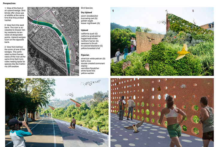
Ecological Infrastructure, Ian Mackay, Ohio State University
Ground nesting birds that are attracted to the riparian corridor are in danger of having their nests washed away in the torrential flows of winter[...]
The west bank abuts the neighborhood of Elysian Valley where stairways and terraces that access the river were proposed. The west bank can thus be considered the “people’s bank.” The east bank, on the other hand, is almost cut off from Cypress Park by the Metrolink Facility site. Access to this bank, which includes the wedge habitats would remain less available. Pathways would run alongside the wedges and be used by only those who truly wish to be there—like birdwatchers. Linking the two banks and soaring above the rich soft bottom ecology that divides them, the bridges bring it all together: people, birds, and the LA River.
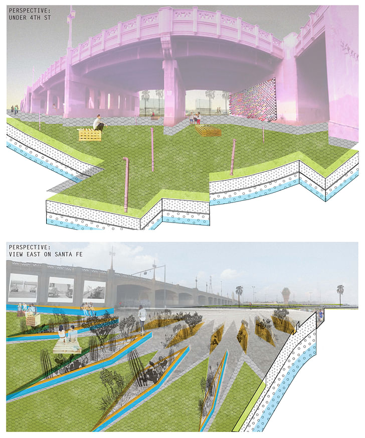
Performative Punk Playground, Rachel Vassar, University of Virginia
Performative Punk Playground responds to the physical and cultural conditions of the site (creating) highly urbanized landscape, views of/from the bridges that form site boundaries, creative institutions and businesses, and outdoor spaces for recreating – to create a venue for artistic expression, experimentation, recreation, and celebration. At the watershed scale, the project re-establishes a dialogue between the river channel and the urban fabric, bringing some of what each does best to the other.
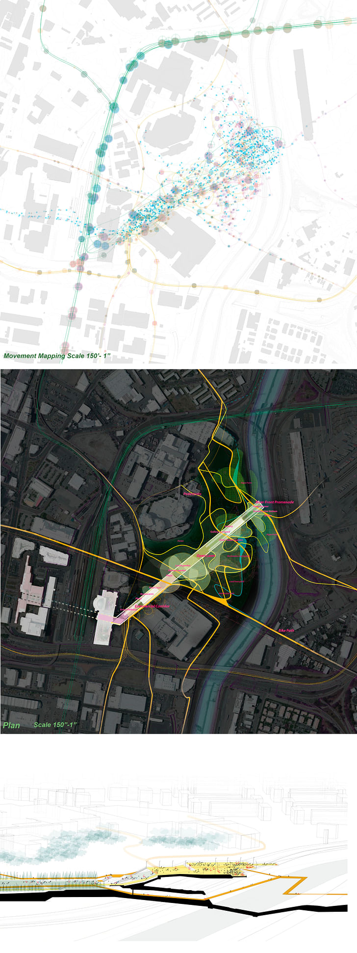
Los Angeles Central Park, Chunlan Zeng, University of Pennsylvania.
The LA River is an opportunity to become a place that the diverse populations can all enjoy… passing through three major areas; commercial space, open space, and water front. Through different activities and events, moving up or down, the LA River is finally revealed and celebrated at the end of their journey.
Former Managing Editor and Podcast Co-Producer for Archinect. I write, go to the movies, walk around and listen to the radio. My interests revolve around cognitive urban theory, psycholinguistics and food.Currently freelancing. Be in touch through longhyphen@gmail.com
4 Comments
It is good to see the focus on this issue. Any article on this topic should reference "Eden by Design: The 1930 Olmsted-Bartholomew Plan for the Los Angeles Region" edited by Greg Hise and William Deverell. UC Press 2000. The opportunity to redevelop the LA River was first introduced to me the same year by SCIArch graduate Alan Loomis who is now the Urban Planner for City of Glendale. In his presentation Alan developed a seasonal flooding strategy that would allow river overflows onto City streets paved with permeable paving used for street markets and parking. A mixed use zone. Ironically, most of the concrete basin projects built by the Army Corp are a few feet too low to actually prevent a 100-year flood event. Irony aside, new projects and thinking might benefit from a look at Olmsted-Bartholomew's plan (and weep for the lost opportunity) and other historical studies before rolling up sleeves to convince the Army Corp to revisit its failed strategies for the LA River. The Corp did eventually come around in New Orleans and Florida's inter-coastal waterways. Great, visionary ideas to spend tax dollars on green redevelopment require a tremendous amount of political persuasion and leadership - a fact that Olmsted & Bartholomew and others over the decades have discovered - chronicled in "How Eden Lost its Garden" by Mike Davis. There are currently EPA studies to clean-up the brown-fields in this forgotten corridor. Synergies abound.
Thanks for expanding the history of this discussion, Richard -- I'd love to see an explicit adaptation of the Olmsted-Bartholomew plan to the Millenial-era LA, as parkland nowadays has to be re-appropriated for the most part, rather than simply preserved/developed. Alan Loomis covered these topics back in 2000; thanks for bringing him up. If the Olmstead-Bartholomew plan was indeed swept under the rug because the commissioners feared its implementation would require a too big, too scary Parks Dept. (LA Times), then involvement from student-citizens and local advocacy groups is even more important, just to communicate how wide the responsibility of these projects rests across many departments/parties, not just Parks.
Great links! Thank you! Some day I would like to see the original maps of the Eden plan at City Clerk. Somewhat related (and why I was focused on this topic) I have been considering an area-wide study for the remediation and redevelopment of public and privately owned "brown-fields" in LA County, and how these sites may continuously aggregate, relate, or connect to existing parks, publicly owned lands, and water ways. Definition: Brown-fields are contaminated (or perceived to be contaminated) sites throughout the country and some regulated by EPA while others are State with EPA monitoring. The EPA is awarding grant funds for site assessments and planning studies. The State keeps a database of sites at http://www.envirostor.dtsc.ca.gov/public/ The 88 cities in the county have various levels of interest and staff assigned to brown-fields, but for the most part it is a dark corner of the planning world that could yield benefits: cleaning up the environment, creating parks, and reclaiming 'troubled' real estate assets for the county tax rolls.
Interesting....
http://www.johnsonfain.com/urban/41#
1993 - Progressive Architecture, Citation Award for Urban Design.
1993 - AIA / Los Angeles, Citation Award for Urban Design.
A Greenways Plan for Los Angeles proposes the use of readily available underutilized land resources within existing infrastructure systems to provide a significant increase in public open space. The plan views active and abandoned transit/rail right-of-ways, transit lines, bikeways, river estuaries and flood control channels and power line easements as elements in a country-wide linear open space system. The plan links the proposed open space system to existing town centers, schools, libraries, post offices and senior centers as well as providing sites for new facilities. The concept can be the catalyst for establishing additional public parks, squares and plazas thereby increasing the amount of open spaces available for the use and enjoyment of the public. As Los Angeles intensifies with new residences and commerce, the plan provides opportunities for a wide range of developments to be associated with a corresponding amount of park development.
Acknowledgements: Progressive Architecture Magazine Award; Exhibited at the Urban Revisions Show, MOCA
Block this user
Are you sure you want to block this user and hide all related comments throughout the site?
Archinect
This is your first comment on Archinect. Your comment will be visible once approved.