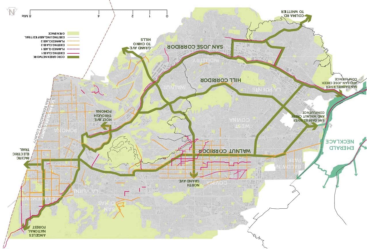
Catalyzing Connectivity: Rediscovering Creeks in the East San Gabriel Valley is a conceptual vision plan that proposes improvements for mobility and access to open space. Seventy-four miles of green network are outlined with 22 miles of overlap with existing and planned infrastructure for a combined total of 158 total miles of green network. Regional links and design interventions are the result of analysis of existing plans, inventories, and stakeholder feedback. Managing automotive circulation is a major challenge in the Los Angeles Region and the East San Gabriel Valley. Seventy-four percent of all travel in the county is done in single-occupancy vehicles, and the infrastructure designed to serve them is the county’s largest consumer of land with the greatest combined environmental impact (Southern California Association of Governments 2012). According to the Los Angeles County Department of Regional Planning, automotive circulation and traffic congestion are the biggest economic issues in the East San Gabriel Valley (2012). Every 10% decrease in traffic congestion has resulted in the creation of up to 135,000 jobs (Southern California Association of Governments 2012). People in auto-oriented communities drive more, walk less, and are more obese than people living in walkable communities (Safe Routes to School
National Partnership 2011). Health issues such as cardiovascular disease, diabetes, and depression are worsened by long commutes and poor access to community services, parks, and open space
(Jackson 2003, Giles-Corti 2006). In addition, these communities tend to exclude access to employment, services, and education for those with low-incomes and disabilities, as well as children and seniors (Dodson, Gleeson, and Sipe 2004). This has been evident in Los Angeles County and parts of the study area (Garcia, Strongin, and Brakke 2011). Solutions require strategic, long-term investments in infrastructure to increase access to existing nonautomotive transit options, while augmenting existing networks with new corridors. The East San Gabriel Valley is located on the eastern edge of Los Angeles County in Southern California between the San Gabriel Mountains and the Puente Hills. Los Angeles has defined and developing north-south trail corridors from the mountains to the ocean but lacks east-west connections across the county. Experts and stakeholders identified potential along the Walnut and San Jose Creeks to improve open space, and to help form these regional links. The project area is 196 square miles and is defined by the subwatersheds of these tributaries of the San Gabriel River. In addition to regional and county plans, many incorporated cities have jurisdictions in the area, and those directly adjacent to the creek corridor are specifically explored and included in the project boundaries. These ten cities are: Baldwin Park, La Puente, Walnut, Industry, West Covina, Covina, San Dimas, La Verne, Claremont, and Pomona.
Status: Unbuilt
Location: East San Gabriel Valley
My Role: CCRC team member
Additional Credits: Project for: The Watershed Conservation Authority and the Regional Mountains Conservancy
CCRC team: Alex Fagnan, Michele Montano, Johnathan Perisho, Yoo-Jung Yang