ASTANA EXPO 2017 IS A INTERNATIONAL SPONSORED ARCHITECTURAL COMPETITION ON CONCEPT DESIGN OF EXPO 2017 SITE, INCLUDING ARCHITECTURAL OBJECT AS THESYMBOL OF EXPO2017 IN ASTANA, KAZAKHSTAN
TARGETS
The project proposed pursues the main objective of the competition for the EXPO 2017 that will be held in Astana, the modern capital of Kazakhstan, designing an area where the architectural symbol of the future ASTANA EXPO 2017 will feature as unique and distinguishable, as icon and identity landmark of the event, and projected into the future that will last over time.
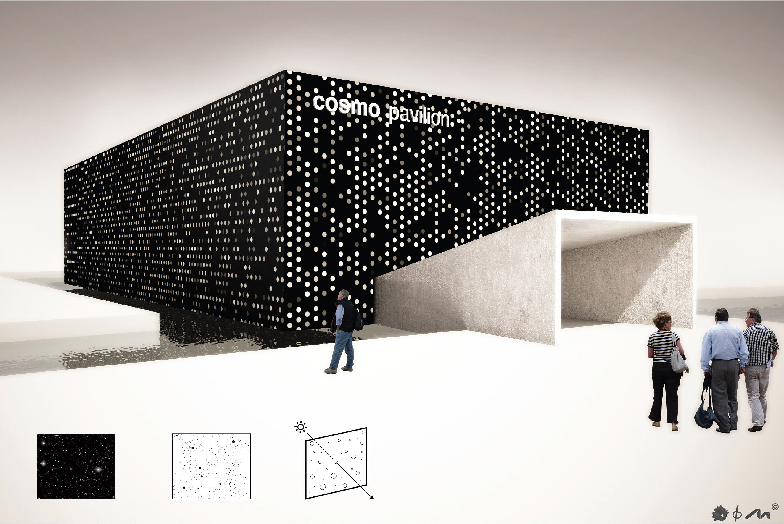
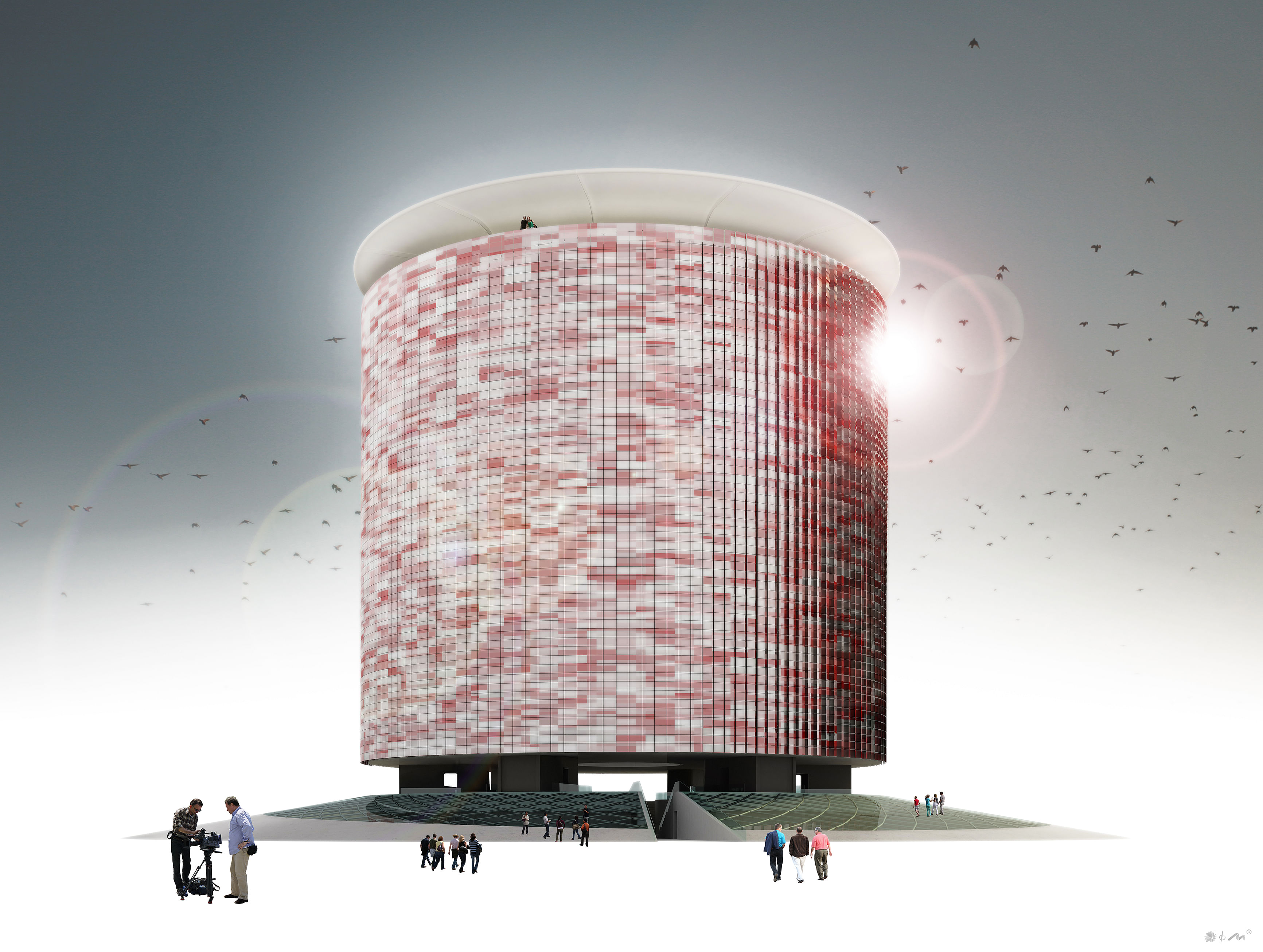
The symbol of ASTANA EXPO 2017 coincides with the same pavilion of Kazakhstan, performing as exhibition center , and becoming the core of all urban planning and architectural composition of the new district.
In the new district called EXPO CITY, all the technologies related to the so-called Future Energy, as stated in this call for proposals and ensued from the Third Industrial Revolution and Green Economy paradigm, will be applied: bioclimatic architecture, technologies and energy efficiency systems, energy recovery, storage and use of rainwater, solar energy and wind, are the main points.
The system of mobility in the project has been sized to meet the quantity and the different types of accesses provided for scheduled daily visits and exceptional accesses to the EXPO. Both within EXPO and the future EXPO CITY, the project endorses sustainable mobility, ehnancing the usage of electric cars and bicycles, and the pedestrian area as well. Moreover, The whole area is a smart city where homes, places of work, culture and education, are particularly integrated and interactive, in an architectural complexity that contains them. This call arises problems as the use of the urban complex “post EXPO”, given the importance of the investment.
The project is in line with the forecasts contained in the addendum to the competition, specifyingd urban and architectural structures and uses, looking for the best links with urban areas of recent construction on the edges, as the University, the Green Line, the sector of the hospitals and, to the south, with the open territory.
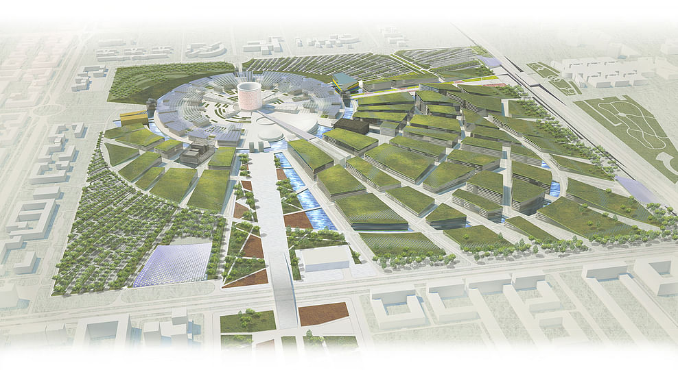
URBAN PLANNING OF THE FUND EXPO
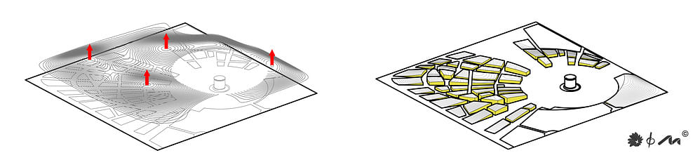
The project stems from the suggestion given by the brief of a drop shape that recalling the limitations of the use of fossil energy, harmoniously connected to the environment and its elements emerging (green axis, university, hospital) and linked by a ‘high-iconic shape. The characteristics of this place 4 km from the center of Astana, almost square with sides of 1,3 KM and a surface dimension of 173.4 ha, completely flat, with vegetation typical of this part of the planet, however, determine its precise “genius loci” that the project seeks to understand and express, even while re-shaping it. The flat surface, is cut with lines converging to the center in several flaps that, by maintaining the finish of the green surface similar to the current, are raised in a different way starting from the four outer edges, to form a sort of perfectly circular inner crater, offset from the center of the square, where different volumes rise.
These artificial hills built with an outer surface of green roofs, in continuity with the wider environment, protect the underlying volume to house the new city, presenting a geological formation that is found in different areas of the Kazakh territory, maintaining the essence and the soul of the place. The overall organization of the sector Expo includes:
- Keeping the EXPO SITE area in a circular shape with, at its core, the Kazakhstan pavilion, also thought of as a symbol of EXPO 2017, with the four thematic pavilions built in proximity of the four main entrances, this way creating a circular ring around the central pavilion useful to the participating nations pavilions of and to aal the different services. This area of about 250 hectares, located in the southeast quadrant of the sector intervention, is surrounded by a pool of water that constitutes the fence and is accessible only through the four doors.
- Structuring the north-east and north-west of the EXPO CITY on an urban plan drawn on a grid of radial axis roads spreading from EXPO SITE. These axes, with different sections and route, are connected to each other differently, and are all connected by a ring that embraces the circular ring del’EXPO resembling the shape of a drop-oriented from south-east to north-west. - The blocks covered in green, mainly from the north-west and north-east, lift from the road edge (Kabanbai batyr avenue and 27th Street) to
the south and take on a wavy pattern, ending with a height five to six floors at the “water crown” of the EXPO site.
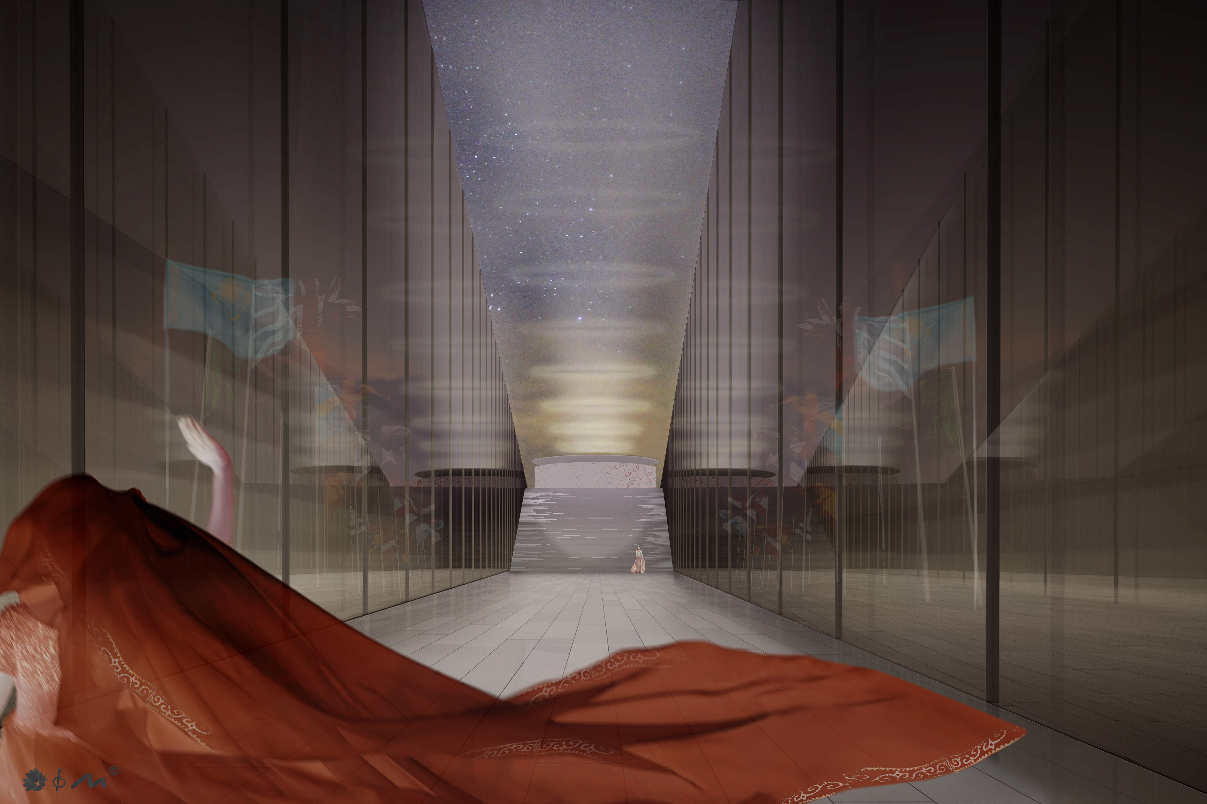
- Extending in a north-south direction the Green Axis coming from Baiterek tower and also touching the Botanic Center. A large pedestrian bridge connects the areas bypassing Hussein bin Talal Street. Narrowing of this Explanade with pedestrian paths delimits the various “green rooms” with different shapes and colors in the direction of the central pavilion of Kazakhstan therefore directing and extending the perspective on the pavilion itself. Baiterek tower and the new pavilion of Kazakhstan are the main focuses in the
new visual axis over 4 kilometers long.
- Extending the Green Axis designed with the same environmental characteristics towards the the Nazarbayev University. In this case the perspective opens from the center of EXPO to encompass the entire facade of the university building, constituted by the central body and dome and the two lateral exedras. To give visual and functional continuity to this great green axis the entire strip of land is lowered by about ten feet below the LRT area, surfacing back to the garden ground in front of the existing university. This choice, combined with the the burial of Kabanbai batyr avenue at this height, not only provides visual continuity from the end of public green and prospects between the two terminal buildings, but also allows functional continuity to pedestrian, cycling and electric vehicles paths between the universities and EXPO buildings that, after the event, will become the technological-scientific center.
- Placing a water basin side by side to the drop-shaped road network in the north west of the sector and the creation of another wider green line coming from the Baiterek Tower, in order to extend the pleasing effects of this primordial element, even n the most built-up parts of the sector.
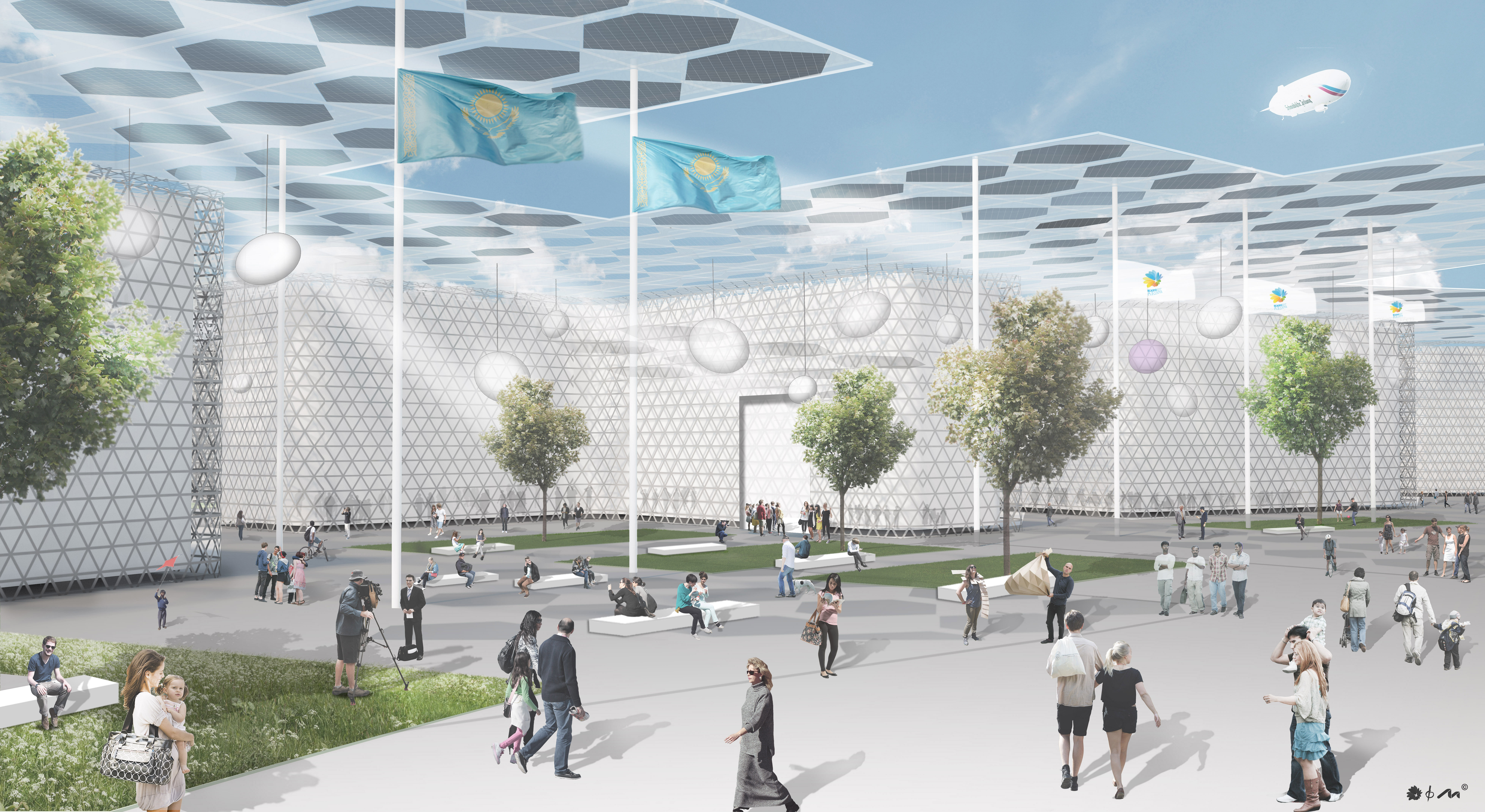
- Considering of fundamental importance the presence, all around the Expo ring, of a glass and steel cover protecting the lower halls and the internal paths from heavy winter weather and climate changes. This large covering, about 100,000 square meters, becomes not only a architectural element but also an urban element and is independent from the pavilions that might be built also in wood or lightweight technologies easily: this choice is the key to the reuse of the structures to have them transformed into laboratories for the future technological center.i
One can easily figure the indoor environment as a large greenhouse that allows a comfortable dwelling even in unfavorable weather conditions being both designed to minimize the need of air treatment and equipped with high-efficiency heating and air conditioning plants.
- Confirmation of the viability at boundaries, mostly with regard to the system the different roads that surround it, as provided for in the master plan of the city of Astana, and the assumption of such estimates in the proposed project, to ensure and resolve how to access to the EXPO.
- In Kabanbai Batyr Avenue, which passes over Hussein bin Talal Street and 27ST Street, will be dug a tunnel about 140 mt long under the green link between EXPO and University, with a special underground lane to Turar Ryskulov Street (30st Street) to enter from the west in EXPO SITE and another one opposite to the previous for those coming from south lane to enter EXPO city.
One can easily figure the indoor environment as a large greenhouse that allows a comfortable dwelling even in unfavorable weather condition being both designed to minimize the need of air treatment and equipped with high-efficiency heating and air conditioning plants.
- Confirmation of the viability at boundaries, mostly with regard to the system the different roads that surround it, as provided for in the master plan of the city of Astana, and the assumption of such estimates in the proposed project, to ensure and resolve how to access to the EXPO.
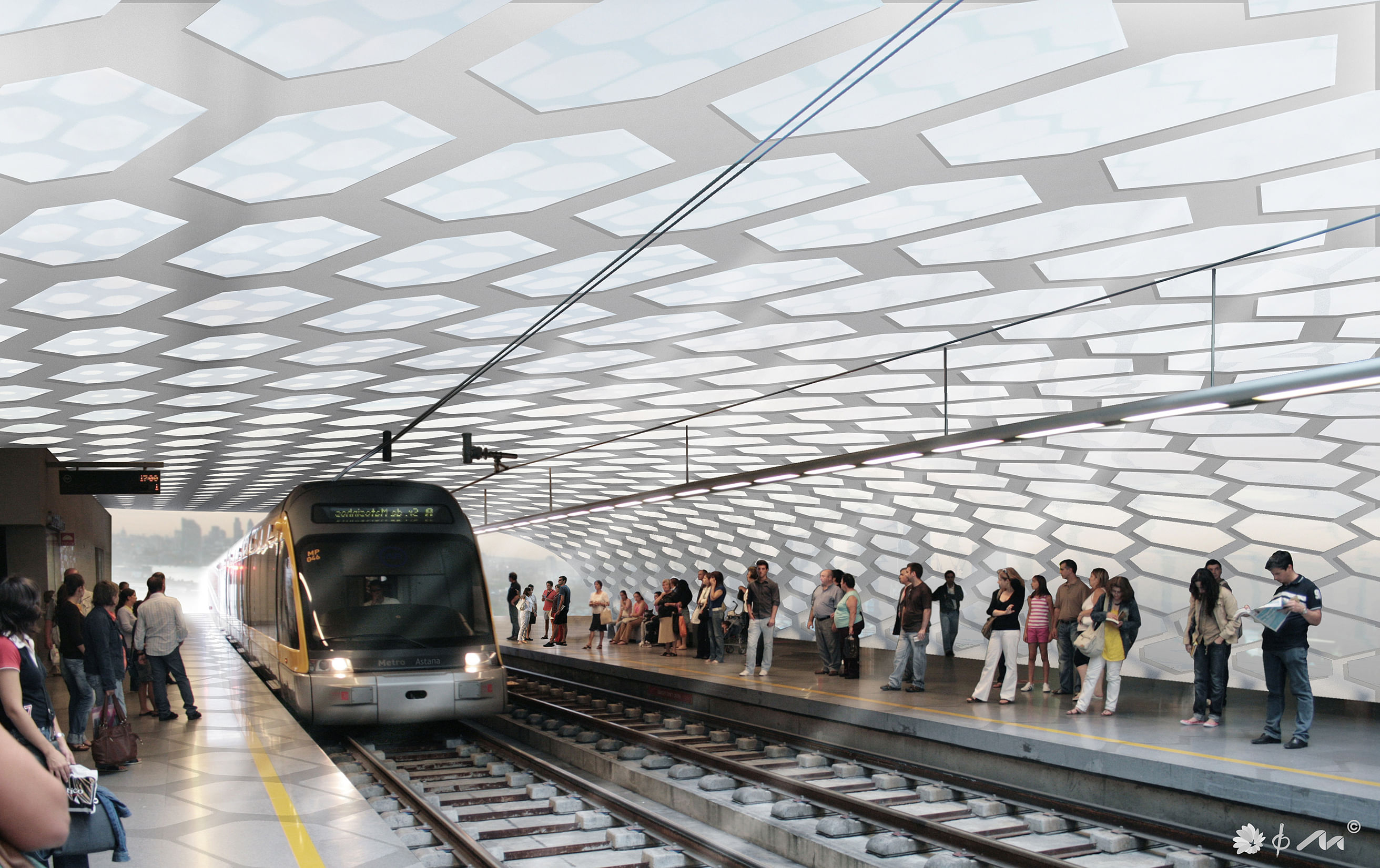
- Confirmation of the light rail line LRT surface prediction of both n 105 and n 106 stops as in the original plan provided for LRT SYSTEM and not just one station as in the Master Plan document attached to the invitation. This is because it is believed that, in the future, once theentire EXPO CITY is completed and given the number of inhabitants settled, both stops will be needed. At first only the southern one, deliberately positioned on the side of the visual cone between the Kazakhstan pavillion and the front of the university building, is thought to be necessary.
The second station, next to the intersection between Kabanbai Batyr Avenue and Hussein Bin Talal Street, will be servicicing prevailing the EXPO CITY and will function properly once everithing is completed and fully functional. Both stops are thought as nodal points of interchange where you can have access to electric vehicles (bikes or mini-car) that allow you to move freely in the expo and the EXPO CITY and leave conventional transportation. They’re covered by structures in hexagonal modules and integrated with photovoltaic surfaces that characterize the shape and identify their function.
- Confirmation of the station for buses and taxis as in the Master Plan document in the north east, accessible from Hussein bin Talal Street (27ST Street.) at the side of the Green Axis. Its characteristics are identical to those of the LRT stations, and its location on the side of the green explanade north access, makes it a privileged access point to the event.
- Localization in the south-east and southwest of the largest private car parks. There will be a parking lot for tourist buses with an area of 50,000 sqm near to the university’s LRT station parking, some 100,000 sqm at the south gate of the Expo, a two-storey car park for 60,000 sqm covered by a hill and near to the previous one. An additional 30.000 sqm private cars parking surface is planned at north with access from Hussein bin Talal Street (27ST Street.) near to the bus and taxi station. Alongside the latter area there will be a parking lot 34.000 sqm for customers and participants, a car park of 5,000 m for supplier and a 5,000 sqm one for the warehouse.
- The main parking areas are paved with “clay courts” technology, tree-lined, to be easily converted, after the EXPO which takes place in the summer, in a public park and green sport areas.
DESCRIPTION OF THE RETICULAR SPACE FRAME ELEMENTS
The reticular space system is made with two structural layers connected with diagonal bars The upper chord layer elements have a rectangular hollow section in order to offer a good resistanc at the bending moment action, in fact the uppe chord elements are loaded directly by the loads acting on the roof cladding The lower chord elements are circular hollow section bars connected with spherical nodes in order to ensure a perfect inge connection. The cladding system is made with metal sheets in the opaque zones and with ETFE cushions or glass plates in the transparent areas.
Struttura
The main structural system is composed by the following elements:
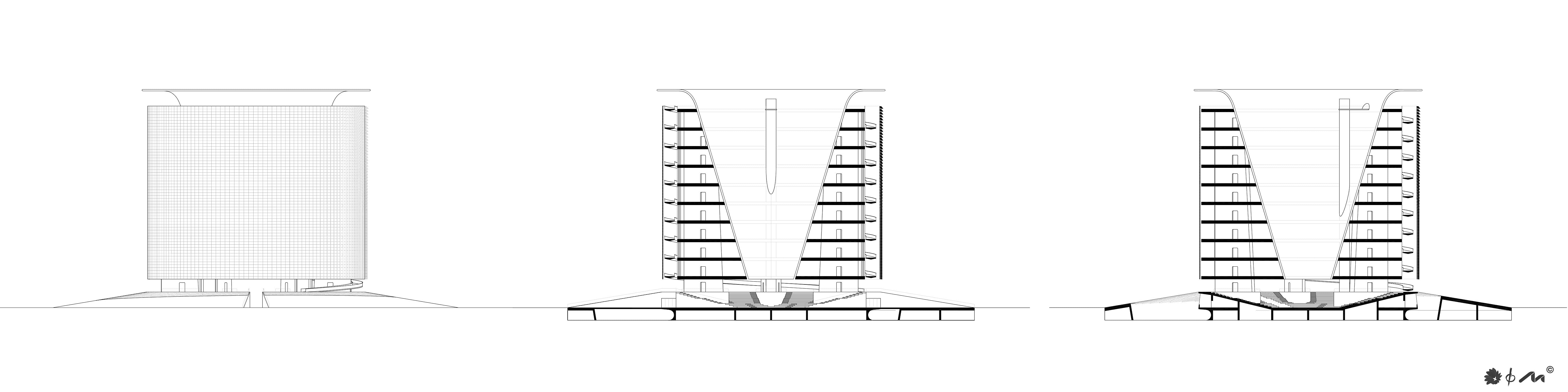
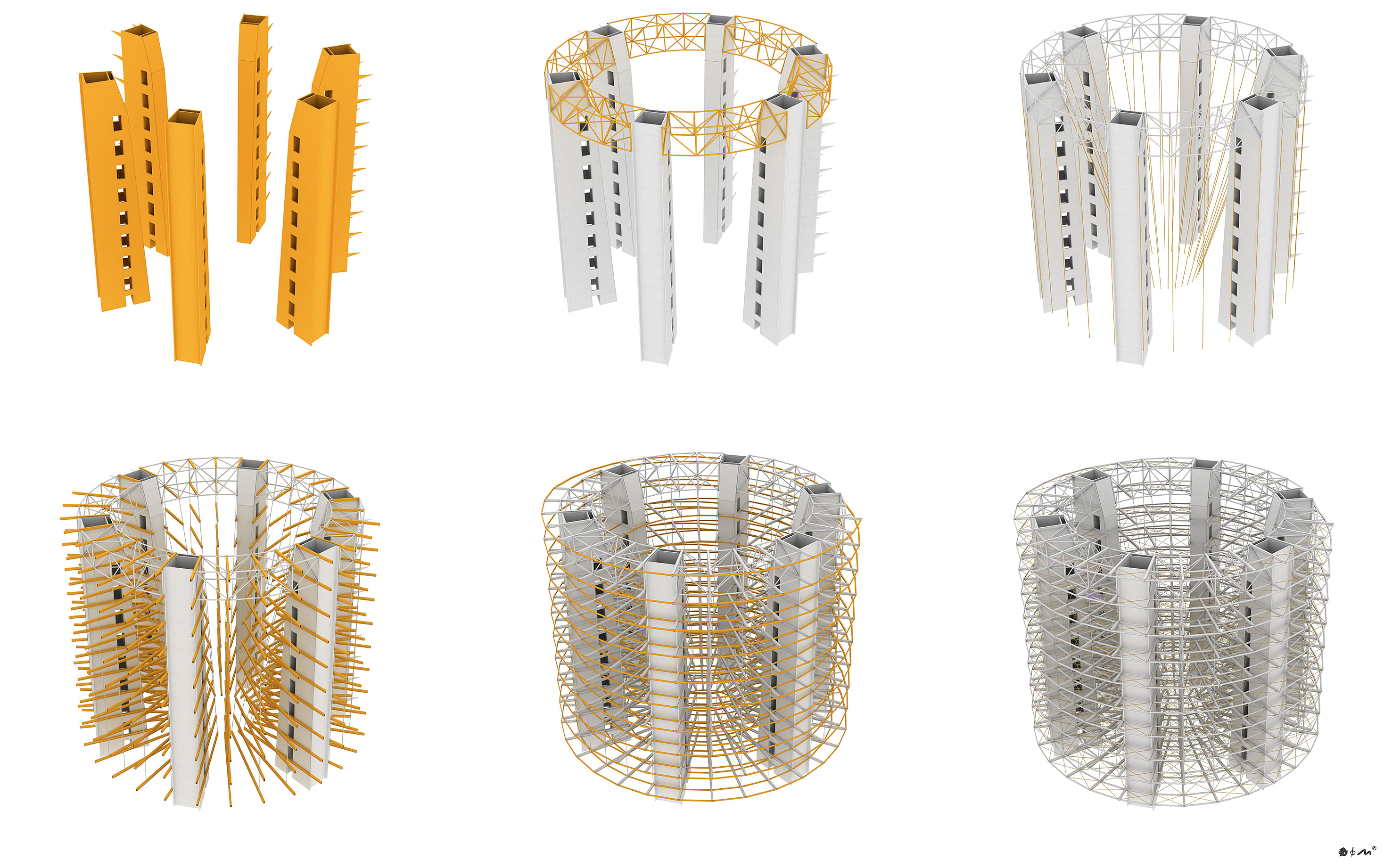
• Six concrete cores used for the stairs, the elevators and the mechanical and electrical plants. The structural function of the cores is to ensure the resistance of the building against the horizontal actions and to transfer at the ground all the vertical forces.
• The floors are composed by steel beams supporting a concrete slab with a trapezoidal metal sheet. The steel beams are connected to the concrete slab with joints in order optimize the structural efficiency.
• The floors are supported by cables connected to a reticular space frame placed in the top of the building . The reticular space frame is composed by circular hollow sections profiles with diagonal bars in order to ensure a good torsional and bending stiffness.
• The external ramp is supported by concrete cantilever beams connected to the concrete core. These cantilever beams have a riangular shape in order to optimize the structural behavior
• The facade cladding system is connected to the floors and stabilized with a bracing system as shown.
SUSTAINABLE CITY
In accordance with the statement of th competition, EXPO 2017 “Future Energy” is not just an event but a unique global project of “Sustainable City” both during the show and afte it: this project pursues this result on the basis o the characteristics described below.
Terrestrial coordinates: latitude 51°, longitude 71°.
London-Paris-like solar heat.
Winter: long and harsh; average temperature -15°C with lowest peaks at -30°C. Copious snow starting from October with peaks in November and disappearance at the end of March.
Summer: mild; average temperature +20,9°C with highest peaks at + 30°C in July. July is characterised by heavy rains even though the summer is mostly sunny.
Winds: in summer wind allocation is wide, while in winter it is mainly south-west oriented. Wind speed is 4,8 m/s on the average.
STRATEGIC APPROACH
Energy demand has to be covered by renewable energy. Renewable energy production requires the availability of large areas for:
- Directly absorbe solar energy for producing hot water (solar-thermal) and electricity (photovoltaics) using collector devices integrated into the architectural context
- Produce electricity using ground wind generators.
- Accumulate solar energy through the harvest of biomass obtained by the handling of the green areas. Biomass will be transformed in biogas and possibly stored as liquid biomethan.
Problems: Large quantities of energy are needed for winter heating, when direct solar energy for producing both photovoltaic electricity and hot water is scarce.
Photovoltaic and wind energy integrated with biomethan combustion when required, should completely cover the total electrical emand when it is not linked to the winter and summer conditioning.
Advantages: Sunny but fresh summer does not require the use of large energy amount for the cooling. Exceeding energy can be used to store energy in batteries or to liquify biomethan during summer. The energy for summer cooling will be store during the harsh winters. Calories for winter heating will be stored during the sunny summers.
Storage the summer heat for winter heating and the wintriness for summer cooling is strategical to reduce the electrical demand for supplying the heat pumps. Biomethan produced through biomasses can produce both electricity to cover the peaks of
electric energy demand and heat to be stored for the winter conditioning. The electric network of the whole area must be
duly dimensioned according to the Smart Gri criteria so to optimise all intakes deriving from different production technologies, energy demand and peaks of power Energy consumption in the EXPO area is so different that it must be separated from the ones of the CITY area. The CITY area must in fact be self-contained while the EXPO area could require a minor external contribution from the national gas and electrical energy network in order to cover the peaks of consumption in some periods during the year.
Energy requirements in the EXPO area are s varied that it must be separated from the CIT area. The CITY area must in fact be totally autosustainable while the EXPO area could require a minor external contribution from the national gas and electrical energy network in order to cover consumption peaks in certain periods of the year.
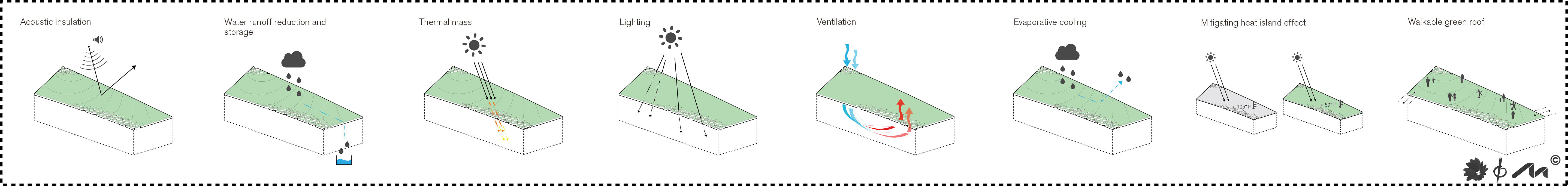
Intensive green roof with hanging gardens which permit tree and bush planting. This type of roof is very heavy (350 kg/m2) and supports 30-40 cm deep quality soil. These characteristics are necessary for regular. maintenance, granting full accessibility and
usability. The roof is to be planted with highl productive mowing grass suited for cool and fertile grounds. An example could be provided by ryegrass (Lolium multiflorum), a mowing grass which germinates starting at 1-2° C and presents optimal growth conditions between 18 and 20° C; these are the typical temperatures of the examined area in spring-summer-autumn. With a correct agronomic technique the ryegrass can produce up to 40-50 tons of green grass per hectare, which gives roughly 8-10 tons of dry matter in a
single mowing and a total of 10-12 tons per year in two mowings.
POST EXPO
The proposed project includes a table that describes specific POST EXPO predictions. instructions contained in the Master Plan
addendum “Post-EXPO Use mode” has been followed, including the same amount of Gros Floor Area Key figures in the table attached Inside the EXPO SITE the volumes occupied by the pavilions of different nations become the venue of a technological and scientific centre extended on 97,000 sqm of Gross Floor, completed by the blocks outside the EXPO SITE along the axis toward the university for another 126,000 sqm of Gross Floor. In the EXPO SITE, pavilions and thematic structures for a global amount of 52,000 sqmof Gross Floor, are converted into cultural centers, museums, concert halls.
In the EXPO CITY an expected total amount of 581,000 sqm of Gross Floor is destined to mixed use, including about 60,000 sqm for
residential use, located in the north east, adjacent to the residential area of Orynbor Avenue and a commercial complex of 20,000 sqm neext to this. In the north west of EXPO CITY all isolates are of mixed use; the Convention center endures its function and 39,000 sqm of Gross Floor are planned with hotels and hosting facilities.. The surface parking areas undergo the most relevant ransformations. Most of the tourist buses parking area (50,000 sqm) and that for cars (100,000 sqm area), located in the south, near
the first station of LRT, are being transformed into an urban park that can suit flexible purposes, and both the users of the new science and technology center that overlooks it, as well as all the hospitals in the south can take advantage from it.
There is still a two floors parking available for these two areas, about 60,000 sqm under the green hill already built for the Expo event, in the south east area on the side of Turar Ryskulov Street (30st Street). The surface parking for private cars, 60,000 sqm, located in the north east side of the public buses and taxis station, is instead turned into the sport area of the district, functional to the new residentia use of the post EXPO and the surrounding Orybor street. The area Near the second LRT station is provided with a second floor parking below the hill, with green coverage on an area of 20,000 sqm. This parking area is at mixed use area’s diposal, as a
point of interchange with electric and conventional transports which can work when the urban load of this part of the urban complex will be in full swing.
Status: Built
Location: Astana, KZ
Additional Credits: THE TEAM
Project Manager & Chief Architect
– Arch. Marco Prodi
Team Designers (Officio Architettura)
– Arch. Davide Pretto
- Arch. Stefano Malfatti
- Arch. Andrea Donini
– Arch. Eleonora Zacchini
– Arch. Margherita Arliotti
– Arch. Edoardo Bernardi
- Arch. Massimiliano Manno
Urban Planning (CCDP):
– Arch. Tomaso Prodi
– Arch. Andrea Malaguzzi
– Arch. Angelo Silingardi
Structures Designers (Studio Majowiecki):
– Prof. Ing. Massimo Majoviecki
– Ing. Giovanni Berti
Alternative energy system:
– Prof. Ing. Leonardo Setti
Landscape architecture:
– Prof. Alberto Giuntoli