The image in the first link isn't totally accurate. Most subways in NYC are directly below the street level, down only one flight of stairs from the sidewalk.
Of course, there are exceptions, such as where tunnels go much deeper underground to get underneath a river (High Street - Brooklyn Bridge on the F line is a good example of this), or where the surrounding topography rises in elevation while the subway line remains relatively level (190th Street on the A line). There's also a few cases where subway lines must dive under other lines, such as the #7 platform at Times Square.
Here's what I know about the depths of Manhattan subway tunnels, and some of this will apply to certain lines in the outer boroughs as well:
First, you need to know the distinction between the three former divisions of the subway: The IRT, BMT, and IND. These were the three competing subway systems that were eventually merged to create the system we know and love today.
The IRT (Interborough Rapid Transit) is the oldest part of the subway, and is comprised of all the numbered routes on today's system as well as the Times Square-GCT shuttle. With a few exceptions, these are very shallow cut-and-cover tunnels. ("Cut-and-cover" means they basically dug a huge trench down the middle of a street, laid down the tracks, and then decked it over.) Unlike the lettered routes of the BMT and IND, the IRT division has much smaller trains and much tighter clearances.
Exceptions to cut-and-cover on the IRT:
- Anywhere the tunnels go under a river, such as the 2/3 and 4/5 trains to Brooklyn, the 7 train to Queens, and the 2, 4, and 5 trains to the Bronx.
- The 1 train goes above-ground to cross a broad valley at 125th Street. Essentially, the tracks stay level while the topography drops away. I think the 125th Street station is something like 50-80 feet above street level.
- The 1 train goes deep underground roughly between 168th Street and 191st Street. Again, the tracks stay relatively level while the topography above rises steeply in Washington Heights. IIRC, the 168th Street platforms are about 100 feet below street level, and can be reached by elevator only.
- The 1 train goes above-ground once again at the northern tip of Manhattan, beginning at Dyckman and staying above-ground until the end of the line in the Bronx.
- The 7 train is fairly deep underground because it runs crosstown, and must go underneath other subway lines that run north-south.
- On the Upper East Side, the express tracks carrying the 4/5 lines run deep underground, directly below the local tracks carrying the 6 line.
- The City Hall station on the 4/5/6 line has an abandoned platform on a lower level loop track. This platform has very ornate tilework, and was the setting for the giant river of pink slime in Ghostbusters II.
Moving on to the BMT and the IND, which are today's lettered routes. Although built to the same specifications and now sharing some routes and equipment, there's still some differences between these onetime fierce rivals.
The BMT (Brooklyn-Manhattan Transit) is the older of the two, itself comprised of several smaller companies. The BMT in Manhattan, like the IRT, usually uses shallow cut-and-cover tunnels, with the station platforms only one flight of stairs down from the sidewalk. BMT stations are also characterized by very ornate tilework along the upper portion of the station walls. BMT lines in Manhattan include the Nassau Street line downtown (J/M/Z), the Broadway line (N/R/Q/W), and the crosstown L line under 14th Street.
The only places where these lines depart from typical cut-and-cover construction is where they go into deep-bore tunnels under the East River, or where they go above-ground to cross over the Manhattan Bridge and the Williamsburg Bridge. Also, the Canal Street Station has a lower level platform for trains serving the Manhattan Bridge, and the City Hall station has an abandoned lower level platform. Also, the L line, because it runs crosstown and must pass beneath other subway lines, is at a deeper level underground.
Next up is my favorite: The IND, or the Independent Subway. This was the beginning of a massive city-owned subway system built in the 1930’s designed to put the IRT and BMT out of business, and was the world’s first truly modern subway system. It featured wide station platforms, an orderly and unified system of signage, and a minimum of curves so that trains could run faster. You could think of it as the prototype for postwar subway systems such as the Washington Metro and BART. Unfortunately, the Great Depression and Robert Moses killed the most grandiose plans for the IND: What exists today is only about a third the size of what was actually proposed. As such, the IND lines feature all sorts of never-to-be-used provisions for future expansion, such as elaborate junctions to never-built lines, and abandoned subway platforms that were never placed into passenger service. For example, the A/C/E station at 42nd Street has an abandoned lower level designed to serve a “super express” service to Brooklyn, and the F line through Carroll Gardens in Brooklyn has seldom-used express tracks on a lower level.
Although the distinction between the BMT and IND is somewhat blurry nowadays, IND stations can be identified by their modernist tile walls (with block lettering and a color-coding system based on express and local stops), wide platforms, and huge station mezzanines that seem to have been designed for much bigger crowds. Although these lines in Manhattan were also cut-and-cover construction, the station depths tend to be deeper due to the addition of a mezzanine level between the platforms and street level. IND lines in Manhattan include the A/C/E line on 8th Avenue, and the B/D/F/V line on 6th Avenue.
Exceptions to cut-and-cover construction on the IND include:
- Places where trains run beneath rivers.
- On the 8th Avenue line along Central Park West, uptown trains operate on upper level tracks, and downtown trains operate on the lower level.
- The station at West 4th Street is a complicated, multi-level junction between the 6th Avenue line and the 8th Avenue line.
- The A/C trains downtown operate on a deep level below Fulton Street, because the tunnel must cross beneath the other subway lines running north-south.
- Up in Washington Heights, the A line runs very deep underground because of the topography between 181st Street and 190th Street. Interestingly, from either of these two stations, you can take an elevator 100 feet up to Ft. Washington Avenue, or a ramp that leads you directly out through the side of the hill to Bennett Avenue.
- On 6th Avenue between Herald Square and West 4th, express trains operate on a lower level while PATH trains operate in a separate tunnel between the IND’s uptown and downtown local tracks.
The IND is unique in that the F line features both the NYC subway’s deepest station below sea level (Roosevelt Island), as well as the highest elevated station above street level (Smith-9th). However, the 116th Street station near Columbia University on the 1 train is at a higher elevation above sea level than Smith-9th on the F, even though it’s underground. Pratt students will know that the IND also contains the G train, the only subway line that never touches Manhattan.
Other odd bits of underground transit infrastructure in Manhattan:
- PATH trains, as mentioned above, run down 6th Avenue before heading to New Jersey.
- Long Island Railroad, New Jersey Transit, and Amtrak trains operate in deep tunnels cutting east-west across Manhattan, linking New Jersey and Queens via Penn Station.
- Metro North trains operate in a cut-and-cover tunnel down Park Avenue to serve Grand Central Terminal. These tracks serve upper and lower level platforms at GCT.
- Construction is underway for a commuter rail tunnel linking Penn Station and GCT, which will allow LIRR and Amtrak trains to serve Grand Central Terminal.
- As was posted here on archinect, construction recently resumed on the long-awaited Second Avenue Subway line. Some portions of this line are already complete, but await the completion of stations and additional tunnels before they can be put into service.
- Somewhere under the intersection of Broadway and Warren Street, near City Hall, is the old Beach Pneumatic Transit line, arguably NYC’s first subway line. It probably would have remained forgotten if Subway (the sandwich chain) hadn’t used images of the line as a theme for wallpaper in their eateries.
i like how it privileges the rail lines, but i think it also assumes a greater knowledge of the city than the standard mta. or maybe i just don't like the font and font size used for the streets on the kickmap.
The only major flaw I see with the map is that it doesn't show PATH, LIRR, or Metro-North lines and stations. Some parts of the Bronx and Queens are actually easier to reach from Manhattan via commuter rail than via subway, and this would be helpful information to have on the map.
I've always had a fascination with trains and transit, and its relationship to the physical form of the city. Most of my transit knowledge comes from having lived in cities with extensive mass transit systems (Chicago, NYC, Philly, etc.), using transit on a regular basis and making lots of observations.
I've also learned a lot from the www.nycsubway.org site, which is loaded with information about mass transit in NYC and elsewhere. Like archinect, that site once had an active discussion board where I learned a ton of stuff from the other people there. (The board was eventually closed because of spam and flame wars, but most of the old regulars still stay in touch via other means.)
i agree with jafidler...if you don't know the city that kick map
is more or less useless..and if you're in a part of the
city you're not completely familiar with the mta map is good
for helping to locate yourself a bit.
I'll have to check that book out... It looks interesting.
As for pneumatic tubes connecting the libraries, I haven't heard about those, but it wouldn't surprise me if such a thing existed. The NY Public Library has several large buildings clustered around the original building on 42nd Street and Fifth Avenue, and a pneumatic tube system would be an effective way of transporting stuff between them. I doubt that such a system would go all the way out to branch libraries further away, though.
A quick Google search also seemed to indicate that many of the post offices in Manhattan are connected to each other via pneumatic tubes, but I didn't have time to look up more specific information.
Lots of weird stuff underneath those streets, and not just the people riding the subways.
Speaking of weird underground stuff in Manhattan, one of the modern office towers in the financial district (I forget which one) has glass-covered openings in the pavement of the plaza, where you can see some colonial-era ruins that were uncovered during the tower's construction.
Also, the destruction of the WTC has exposed some remnants of the old Hudson Terminal building that stood on the site before the WTC was built.
What about any books on above-ground transportation infrastructure, like the streetcars and elevated trains (e.g. the 2nd Avenue/Bowery tracks, now demolished)? Parts of Ric Burns' New York series talked about it, but not in enough detail for my satisfaction. Too bad that it was eliminated.
LIG, from what I understand, those foundations are some of the very few remaining built artifacts of New Amsterdam. New York is a pretty amazing palimpsest; There's little sentimentality about razing. (I just wish they'd stop with the cardboard condo developments in Northern Brooklyn.)
The nycsubway.org site mentioned above has some very good historical information about the above-ground transit infrastructure, including old el lines that no longer exist.
Another good site about NYC's transit infrastructure is nycroads.com, which discusses the area's roads, bridges, and tunnels.
I know that in Toronto, there's a set of tunnels that connect all the hospitals (for quicker patient transport, emergencies, etc.) I wonder if there's something like that in NYC? I liked the idea ever since I heard of it.
I saw a cross section of the World Book Encyclopedia that my father had purchased for myself and brothers. I fit isn't in there it was in one of two sets of Encyclopedia Britannica. I do not know if it was in a section on NYC, NY or not.

manhattan cross section drawing
I remember seeing a drawing a long time ago basically showing a cross section through New York City (showing all the great stuff underground)
Does anyone have a copy of this???
found it...sort of
http://www.nationalgeographic.com/features/97/nyunderground/
more cool stuff
http://www.enviroliteracy.org/article.php/613.html
The image in the first link isn't totally accurate. Most subways in NYC are directly below the street level, down only one flight of stairs from the sidewalk.
Of course, there are exceptions, such as where tunnels go much deeper underground to get underneath a river (High Street - Brooklyn Bridge on the F line is a good example of this), or where the surrounding topography rises in elevation while the subway line remains relatively level (190th Street on the A line). There's also a few cases where subway lines must dive under other lines, such as the #7 platform at Times Square.
NYC subway track maps
Here's what I know about the depths of Manhattan subway tunnels, and some of this will apply to certain lines in the outer boroughs as well:
First, you need to know the distinction between the three former divisions of the subway: The IRT, BMT, and IND. These were the three competing subway systems that were eventually merged to create the system we know and love today.
The IRT (Interborough Rapid Transit) is the oldest part of the subway, and is comprised of all the numbered routes on today's system as well as the Times Square-GCT shuttle. With a few exceptions, these are very shallow cut-and-cover tunnels. ("Cut-and-cover" means they basically dug a huge trench down the middle of a street, laid down the tracks, and then decked it over.) Unlike the lettered routes of the BMT and IND, the IRT division has much smaller trains and much tighter clearances.
Exceptions to cut-and-cover on the IRT:
- Anywhere the tunnels go under a river, such as the 2/3 and 4/5 trains to Brooklyn, the 7 train to Queens, and the 2, 4, and 5 trains to the Bronx.
- The 1 train goes above-ground to cross a broad valley at 125th Street. Essentially, the tracks stay level while the topography drops away. I think the 125th Street station is something like 50-80 feet above street level.
- The 1 train goes deep underground roughly between 168th Street and 191st Street. Again, the tracks stay relatively level while the topography above rises steeply in Washington Heights. IIRC, the 168th Street platforms are about 100 feet below street level, and can be reached by elevator only.
- The 1 train goes above-ground once again at the northern tip of Manhattan, beginning at Dyckman and staying above-ground until the end of the line in the Bronx.
- The 7 train is fairly deep underground because it runs crosstown, and must go underneath other subway lines that run north-south.
- On the Upper East Side, the express tracks carrying the 4/5 lines run deep underground, directly below the local tracks carrying the 6 line.
- The City Hall station on the 4/5/6 line has an abandoned platform on a lower level loop track. This platform has very ornate tilework, and was the setting for the giant river of pink slime in Ghostbusters II.
Moving on to the BMT and the IND, which are today's lettered routes. Although built to the same specifications and now sharing some routes and equipment, there's still some differences between these onetime fierce rivals.
The BMT (Brooklyn-Manhattan Transit) is the older of the two, itself comprised of several smaller companies. The BMT in Manhattan, like the IRT, usually uses shallow cut-and-cover tunnels, with the station platforms only one flight of stairs down from the sidewalk. BMT stations are also characterized by very ornate tilework along the upper portion of the station walls. BMT lines in Manhattan include the Nassau Street line downtown (J/M/Z), the Broadway line (N/R/Q/W), and the crosstown L line under 14th Street.
The only places where these lines depart from typical cut-and-cover construction is where they go into deep-bore tunnels under the East River, or where they go above-ground to cross over the Manhattan Bridge and the Williamsburg Bridge. Also, the Canal Street Station has a lower level platform for trains serving the Manhattan Bridge, and the City Hall station has an abandoned lower level platform. Also, the L line, because it runs crosstown and must pass beneath other subway lines, is at a deeper level underground.
Next up is my favorite: The IND, or the Independent Subway. This was the beginning of a massive city-owned subway system built in the 1930’s designed to put the IRT and BMT out of business, and was the world’s first truly modern subway system. It featured wide station platforms, an orderly and unified system of signage, and a minimum of curves so that trains could run faster. You could think of it as the prototype for postwar subway systems such as the Washington Metro and BART. Unfortunately, the Great Depression and Robert Moses killed the most grandiose plans for the IND: What exists today is only about a third the size of what was actually proposed. As such, the IND lines feature all sorts of never-to-be-used provisions for future expansion, such as elaborate junctions to never-built lines, and abandoned subway platforms that were never placed into passenger service. For example, the A/C/E station at 42nd Street has an abandoned lower level designed to serve a “super express” service to Brooklyn, and the F line through Carroll Gardens in Brooklyn has seldom-used express tracks on a lower level.
Although the distinction between the BMT and IND is somewhat blurry nowadays, IND stations can be identified by their modernist tile walls (with block lettering and a color-coding system based on express and local stops), wide platforms, and huge station mezzanines that seem to have been designed for much bigger crowds. Although these lines in Manhattan were also cut-and-cover construction, the station depths tend to be deeper due to the addition of a mezzanine level between the platforms and street level. IND lines in Manhattan include the A/C/E line on 8th Avenue, and the B/D/F/V line on 6th Avenue.
Exceptions to cut-and-cover construction on the IND include:
- Places where trains run beneath rivers.
- On the 8th Avenue line along Central Park West, uptown trains operate on upper level tracks, and downtown trains operate on the lower level.
- The station at West 4th Street is a complicated, multi-level junction between the 6th Avenue line and the 8th Avenue line.
- The A/C trains downtown operate on a deep level below Fulton Street, because the tunnel must cross beneath the other subway lines running north-south.
- Up in Washington Heights, the A line runs very deep underground because of the topography between 181st Street and 190th Street. Interestingly, from either of these two stations, you can take an elevator 100 feet up to Ft. Washington Avenue, or a ramp that leads you directly out through the side of the hill to Bennett Avenue.
- On 6th Avenue between Herald Square and West 4th, express trains operate on a lower level while PATH trains operate in a separate tunnel between the IND’s uptown and downtown local tracks.
The IND is unique in that the F line features both the NYC subway’s deepest station below sea level (Roosevelt Island), as well as the highest elevated station above street level (Smith-9th). However, the 116th Street station near Columbia University on the 1 train is at a higher elevation above sea level than Smith-9th on the F, even though it’s underground. Pratt students will know that the IND also contains the G train, the only subway line that never touches Manhattan.
Other odd bits of underground transit infrastructure in Manhattan:
- PATH trains, as mentioned above, run down 6th Avenue before heading to New Jersey.
- Long Island Railroad, New Jersey Transit, and Amtrak trains operate in deep tunnels cutting east-west across Manhattan, linking New Jersey and Queens via Penn Station.
- Metro North trains operate in a cut-and-cover tunnel down Park Avenue to serve Grand Central Terminal. These tracks serve upper and lower level platforms at GCT.
- Construction is underway for a commuter rail tunnel linking Penn Station and GCT, which will allow LIRR and Amtrak trains to serve Grand Central Terminal.
- As was posted here on archinect, construction recently resumed on the long-awaited Second Avenue Subway line. Some portions of this line are already complete, but await the completion of stations and additional tunnels before they can be put into service.
- Somewhere under the intersection of Broadway and Warren Street, near City Hall, is the old Beach Pneumatic Transit line, arguably NYC’s first subway line. It probably would have remained forgotten if Subway (the sandwich chain) hadn’t used images of the line as a theme for wallpaper in their eateries.
not a cross section... but talking about subways maybe a nice link
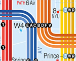
its an alternative subway map.. in my opinion more useful than the existing mta map
http://www.kickmap.com/
Pretty cool... I agree it's a much more useful (and nicer-looking) map. Hopefully the MTA will adopt it someday.
Historical NYC subway maps
i like how it privileges the rail lines, but i think it also assumes a greater knowledge of the city than the standard mta. or maybe i just don't like the font and font size used for the streets on the kickmap.
but it definitely looks sharper than the mta.
The only major flaw I see with the map is that it doesn't show PATH, LIRR, or Metro-North lines and stations. Some parts of the Bronx and Queens are actually easier to reach from Manhattan via commuter rail than via subway, and this would be helpful information to have on the map.
LiG... I would like to elect you Mass Transit Czar of the Universe...
seriously, how do you know so much?
[url=http://www.gutenberg.org/files/18548/18548-h/18548-h.htm]
I've always had a fascination with trains and transit, and its relationship to the physical form of the city. Most of my transit knowledge comes from having lived in cities with extensive mass transit systems (Chicago, NYC, Philly, etc.), using transit on a regular basis and making lots of observations.
I've also learned a lot from the www.nycsubway.org site, which is loaded with information about mass transit in NYC and elsewhere. Like archinect, that site once had an active discussion board where I learned a ton of stuff from the other people there. (The board was eventually closed because of spam and flame wars, but most of the old regulars still stay in touch via other means.)
ups ...sorry for that
I heard that there is a pneumantic tube system that connects many of the libraries in Manhattan to each other....is this true?
i agree with jafidler...if you don't know the city that kick map
is more or less useless..and if you're in a part of the
city you're not completely familiar with the mta map is good
for helping to locate yourself a bit.
if they could combine the two i'd be sold.
You guys ever seen this book?

I highly recommend it....talks all about NYC infrastructure. Fascinating.
hi dubK
hi mdler!
i own said book, it's like a picture book for adults!
I'll have to check that book out... It looks interesting.
As for pneumatic tubes connecting the libraries, I haven't heard about those, but it wouldn't surprise me if such a thing existed. The NY Public Library has several large buildings clustered around the original building on 42nd Street and Fifth Avenue, and a pneumatic tube system would be an effective way of transporting stuff between them. I doubt that such a system would go all the way out to branch libraries further away, though.
A quick Google search also seemed to indicate that many of the post offices in Manhattan are connected to each other via pneumatic tubes, but I didn't have time to look up more specific information.
Lots of weird stuff underneath those streets, and not just the people riding the subways.
that IS is a great book. i went to a lecture by the author, fascinating stuff.
Speaking of weird underground stuff in Manhattan, one of the modern office towers in the financial district (I forget which one) has glass-covered openings in the pavement of the plaza, where you can see some colonial-era ruins that were uncovered during the tower's construction.
Also, the destruction of the WTC has exposed some remnants of the old Hudson Terminal building that stood on the site before the WTC was built.
NY Times article about an amateur subway map designer.
Has anyone seen Dark Days?
What about any books on above-ground transportation infrastructure, like the streetcars and elevated trains (e.g. the 2nd Avenue/Bowery tracks, now demolished)? Parts of Ric Burns' New York series talked about it, but not in enough detail for my satisfaction. Too bad that it was eliminated.
LIG, from what I understand, those foundations are some of the very few remaining built artifacts of New Amsterdam. New York is a pretty amazing palimpsest; There's little sentimentality about razing. (I just wish they'd stop with the cardboard condo developments in Northern Brooklyn.)
The nycsubway.org site mentioned above has some very good historical information about the above-ground transit infrastructure, including old el lines that no longer exist.
Another good site about NYC's transit infrastructure is nycroads.com, which discusses the area's roads, bridges, and tunnels.
about the final push to bring LIRR trains from Queens to Grand Central Terminal.

I know that in Toronto, there's a set of tunnels that connect all the hospitals (for quicker patient transport, emergencies, etc.) I wonder if there's something like that in NYC? I liked the idea ever since I heard of it.
I saw a cross section of the World Book Encyclopedia that my father had purchased for myself and brothers. I fit isn't in there it was in one of two sets of Encyclopedia Britannica. I do not know if it was in a section on NYC, NY or not.
BHF
Good thinking Bruce. I am sure the OP of this 10-year old discussion will be pleased to hear about this.
Block this user
Are you sure you want to block this user and hide all related comments throughout the site?
Archinect
This is your first comment on Archinect. Your comment will be visible once approved.